

| Mesoscale Discussion 2388 | |
| < Previous MD | |

|
|
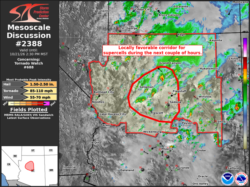
Mesoscale Discussion 2388 NWS Storm Prediction Center Norman OK 0254 PM CDT Wed Oct 21 2026 Areas affected...Parts of central/northern Arizona Concerning...Tornado Watch 688... Valid 211954Z - 212130Z The severe weather threat for Tornado Watch 688 continues. SUMMARY...The severe risk continues across Tornado Watch #688, with a potential focus over parts of Yavapai and Coconino Counties for the next couple of hours. DISCUSSION...The latest radar data from KFSX continues to depict periodic supercells tracking north-northeastward across parts of Yavapai into southern Coconino Counties, where forcing for ascent is maximized with a south-southwesterly low-level jet and related warm-air advection. Similar to earlier this morning, most of these storms locally intensify as they interact with terrain features, where low-level vorticity and mesoscale ascent remain maximized. Given pockets of diurnal heating in cloud breaks and around 150-200 m2/s2 0-1 km SRH (per observed storm motions and KFSX VWP), this area should remain locally favorable for supercells capable of producing large hail, locally severe gusts, and a couple of tornadoes in the near term. ..Weinman.. 10/21/2026 ...Please see www.spc.noaa.gov for graphic product... ATTN...WFO...FGZ... LAT...LON 34541281 34801319 35081327 35461310 35751269 35991214 36001187 35901163 35541143 34641139 34311168 34351212 34541281 MOST PROBABLE PEAK TORNADO INTENSITY...85-110 MPH MOST PROBABLE PEAK WIND GUST...55-70 MPH MOST PROBABLE PEAK HAIL SIZE...1.50-2.50 IN |
|
|
Top/All Mesoscale Discussions/Forecast Products/Home |
|
Source link