

| Mesoscale Discussion 2384 | |
| < Previous MD | |

|
|
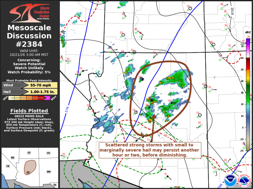
Mesoscale Discussion 2384 NWS Storm Prediction Center Norman OK 0305 AM CDT Wed Oct 21 2026 Areas affected...parts of central and northern Arizona Concerning...Severe potential...Watch unlikely Valid 210805Z - 211000Z Probability of Watch Issuance...5 percent SUMMARY...Scattered strong thunderstorm development posing a risk for small to marginally severe hail may persist another hour or two, north of the Greater Phoenix area into the Mogollon Rim vicinity south of Flagstaff, with diminishing potential through 2-4 AM MST and into/across northern Arizona. DISCUSSION...There has been an increase in number of thunderstorms initiating over the past couple of hours, as a focused area of large-scale ascent begins to spread north of the lower deserts into the Colorado Plateau. At higher elevations across and north of the Mogollon Rim, the boundary-layer moisture increases remain modest, within a relatively cool environment. This is likely to continue to suppress destabilization, particularly as temperatures around 500 mb begin to warm through 10-12z. In the presence of strong deep-layer shear, the environment north of Greater Phoenix into the Mogollon Rim vicinity may continue to support a few storms capable of producing small to marginally severe hail for another hour or two, however this potential is expected to remain more limited with northward extent. ..Kerr/Gleason.. 10/21/2026 ...Please see www.spc.noaa.gov for graphic product... ATTN...WFO...FGZ...PSR... LAT...LON 34241266 36281224 36541009 34970998 33751177 34241266 MOST PROBABLE PEAK WIND GUST...55-70 MPH MOST PROBABLE PEAK HAIL SIZE...1.00-1.75 IN |
|
|
Top/All Mesoscale Discussions/Forecast Products/Home |
|
Source link