

| Mesoscale Discussion 2149 | |
| < Previous MD | |
|
|
   Mesoscale Discussion 2149
   NWS Storm Prediction Center Norman OK
   0143 PM CDT Thu Aug 27 2026

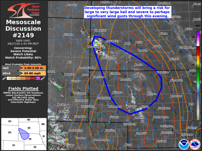
   Areas affected...portions of the Black Hills into northwestern and
   west-central Nebraska

   Concerning...Severe potential...Watch likely

   Valid 271843Z - 272045Z

   Probability of Watch Issuance...80 percent

   SUMMARY...Thunderstorms forming on the Black Hills will evolve
   southeastward through the evening, bringing a risk for large to very
   large hail and severe wind gusts.

   DISCUSSION...Latest surface analysis depicts a corridor of low-60s F
   dewpoints across northwestern Nebraska and southwestern South Dakota
   that have been maintained by moist southerly/southeasterly low-level
   flow. Combined with strong diurnal heating and weak ascent
   associated with a subtle mid-level wave progressing southeastward
   out of eastern Montana, convective initiation is likely across the
   Black Hills within the next 1-2 hours. Supercells will be the
   initial storm mode owing to strong northwesterly flow aloft and
   40-45 kts of effective shear. While some uncertainty remains
   regarding convective evolution (particularly supercell longevity and
   the potential for eventual upscale growth), very steep mid-level
   lapse rates and elongated hodographs sampled by the 18z UNR observed
   sounding will support a risk for large to very large hail (up to
   2-3+ inches in diameter) with any sustained supercells. Severe to
   perhaps significant severe wind gusts of 65-75 mph may also occur
   with these supercells, with a greater threat for severe gusts likely
   to accompany any convective cluster that eventually evolves as this
   activity progresses southeastward. Regardless of the exact storm
   mode evolution, a Severe Thunderstorm Watch will likely be needed
   once convective development currently noted over the Black Hills
   matures.

   ..Chalmers/Mosier.. 08/27/2026

   ...Please see www.spc.noaa.gov for graphic product...

   ATTN...WFO...LBF...UNR...CYS...

   LAT...LON   44280348 43540157 43030059 42710030 42330028 41850058
               41500113 41320192 41520251 42000294 43020345 44050394
               44310382 44280348

   MOST PROBABLE PEAK WIND GUST...65-80 MPH
   MOST PROBABLE PEAK HAIL SIZE...2.00-3.50 IN
|
|
|
Top/All Mesoscale Discussions/Forecast Products/Home |
|
Source link