

| Mesoscale Discussion 2147 | |
| < Previous MD Next MD > | |
|
|
   Mesoscale Discussion 2147
   NWS Storm Prediction Center Norman OK
   1252 PM CDT Thu Aug 27 2026

   Areas affected...south-central and southeast Pennsylvania into the
   West Virginia Panhandle...northern Virginia...and portions of
   Maryland

   Concerning...Severe potential...Watch likely

   Valid 271752Z - 271945Z

   Probability of Watch Issuance...80 percent

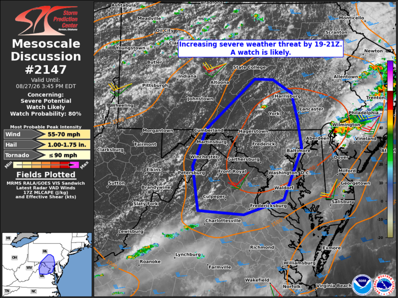
   SUMMARY...The threat for severe thunderstorms capable of damaging
   wind gusts, marginally severe hail, and perhaps a brief tornado is
   expected to increase between 19-21Z. A severe thunderstorm watch is
   likely.

   DISCUSSION...Visible satellite imagery indicates deepening cumulus
   along the high terrain from the WV Panhandle and northern VA into
   portions of south-central PA amidst a warming and destabilizing
   boundary layer with MLCAPE of 1500-2500 J/kg, per latest objective
   analysis. Continued daytime heating coupled with the glancing
   influence of a subtle disturbance passing near and to the southeast
   of the area is expected to support a gradual increase in
   thunderstorms across the discussion area over the next 2-3 hours.

   The degree of instability combined with around 30 kt of deep-layer
   shear will support some storm organization, including possible
   supercell and/or bowing structures, with the primary hazard being
   damaging wind gusts as low-level lapse rates continue to steepen.
   Marginally severe hail is also possible, especially with any
   supercells that may evolve. A conditional brief tornado threat may
   materialize, particularly over northeast MD into far southeast PA,
   with storms developing along or favorably interacting with an
   outflow boundary associated with ongoing storms over NJ, where
   low-level shear may be locally enhanced.

   ..Mead/Mosier.. 08/27/2026

   ...Please see www.spc.noaa.gov for graphic product...

   ATTN...WFO...CTP...LWX...

   LAT...LON   39077875 39737844 40637732 40627690 40387647 39907632
               39407623 38477666 38207758 38277862 39077875

   MOST PROBABLE PEAK TORNADO INTENSITY...UP TO 90 MPH
   MOST PROBABLE PEAK WIND GUST...55-70 MPH
   MOST PROBABLE PEAK HAIL SIZE...1.00-1.75 IN
|
|
|
Top/All Mesoscale Discussions/Forecast Products/Home |
|
Source link