

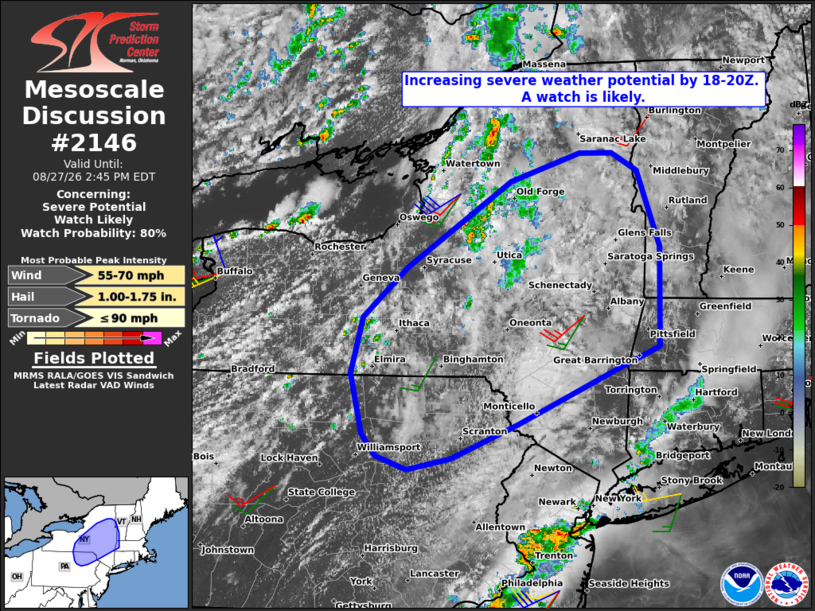
| Mesoscale Discussion 2146 | |
| < Previous MD | |

|
|
   Mesoscale Discussion 2146
   NWS Storm Prediction Center Norman OK
   1151 AM CDT Thu Aug 27 2026

   Areas affected...portions of central and eastern New
   York...northeast Pennsylvania...southwest Vermont...and western
   Massachusetts

   Concerning...Severe potential...Watch likely

   Valid 271651Z - 271845Z

   Probability of Watch Issuance...80 percent

   SUMMARY...The threat for severe weather is expected to increase by
   18-20Z. The predominant hazard will be damaging wind gusts, with
   marginally severe hail and a brief tornado or two also possible. A
   severe thunderstorm watch is likely.

   DISCUSSION...In the wake of early-day showers and thunderstorms now
   shifting east of I-81 northeast of Syracuse, visible satellite
   imagery indicates deepening cumulus development over the Finger
   Lakes into north-central PA. There, cloud breaks have allowed for
   greater air mass destabilization to occur with steepening low-level
   lapse rates.

   While specific details regarding thunderstorm evolution remain
   uncertain, recent model guidance indicates a gradual increase in
   storm coverage and intensity over the next 2-3 hours from west to
   east across the region amidst a warming boundary layer with MLCAPE
   increasing to 1000-1500+ J/kg. A belt of enhanced (30-35 kt)
   westerly mid-level flow observed by the 12Z Buffalo and Pittsburgh
   soundings and current VWPs will yield sufficient vertical shear for
   some storm organization, including bowing and transient supercell
   structures. The primary hazard will be damaging wind gusts, which
   will be most likely in areas that see stronger heating and the
   resultant steepening of low-level lapse rates. Marginally severe
   hail also appears possible. The greatest potential for a tornado or
   two will exist with any supercell structures in the Hudson Valley,
   where backed surface winds will yield a corridor of stronger
   low-level shear.

   ..Mead/Mosier.. 08/27/2026

   ...Please see www.spc.noaa.gov for graphic product...

   ATTN...WFO...BTV...ALY...BGM...BUF...CTP...

   LAT...LON   41447693 42027708 42557692 43047635 43877500 44147411
               44147369 43967336 43237307 42277308 42067366 41547492
               41217577 41107635 41237675 41447693

   MOST PROBABLE PEAK TORNADO INTENSITY...UP TO 90 MPH
   MOST PROBABLE PEAK WIND GUST...55-70 MPH
   MOST PROBABLE PEAK HAIL SIZE...1.00-1.75 IN
|
|
|
Top/All Mesoscale Discussions/Forecast Products/Home |
|
Source link