

| Mesoscale Discussion 2134 | |
| < Previous MD | |
|
|
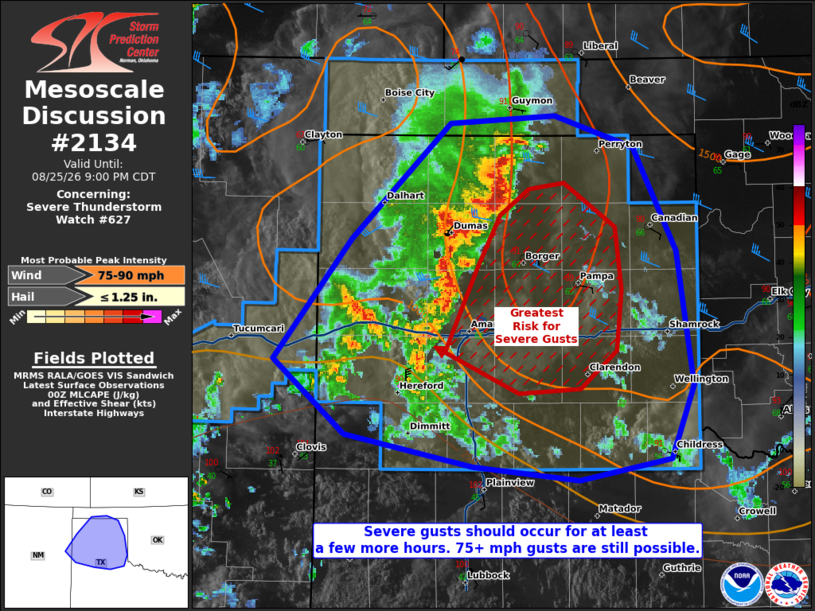
Mesoscale Discussion 2134 NWS Storm Prediction Center Norman OK 0758 PM CDT Tue Aug 25 2026 Areas affected...much of the Texas Panhandle Concerning...Severe Thunderstorm Watch 627... Valid 260058Z - 260200Z The severe weather threat for Severe Thunderstorm Watch 627 continues. SUMMARY...Severe gusts will remain likely over the next few hours. A few additional gusts exceeding 75 mph may still occur. DISCUSSION...A cold-pool-driven MCS, with a history of severe gusts (some reaching 80 mph) continues to propagate southeast. This MCS and accompanying outflow has collided with other outflow boundaries in a seemingly productive manner, with an uptick in reflectivity and wind report frequency trends noted. Ahead of the MCS resides relatively cooler temperatures left behind by outflow from another storm cluster. However, this airmass is still buoyant (e.g. 2000 J/kg MLCAPE still present), and coincides with 30-40 kts of effective bulk shear. As such, severe gusts should continue with this cold-pool-driven MCS, with a few gusts potentially exceeding 75 mph. ..Squitieri.. 08/26/2026 ...Please see www.spc.noaa.gov for graphic product... ATTN...WFO...LUB...AMA...ABQ... LAT...LON 35020339 35820277 36580197 36630113 36420050 35730017 34850003 34370022 34240094 34330179 34530282 35020339 MOST PROBABLE PEAK WIND GUST...75-90 MPH MOST PROBABLE PEAK HAIL SIZE...UP TO 1.25 IN |
|
|
Top/All Mesoscale Discussions/Forecast Products/Home |
|
Source link