

| Mesoscale Discussion 2130 | |
| < Previous MD | |
|
|
   Mesoscale Discussion 2130
   NWS Storm Prediction Center Norman OK
   0457 PM CDT Tue Aug 25 2026

   Areas affected...portions of far southwestern Oklahoma into
   northwestern Texas

   Concerning...Severe potential...Watch possible

   Valid 252157Z - 252300Z

   Probability of Watch Issuance...40 percent

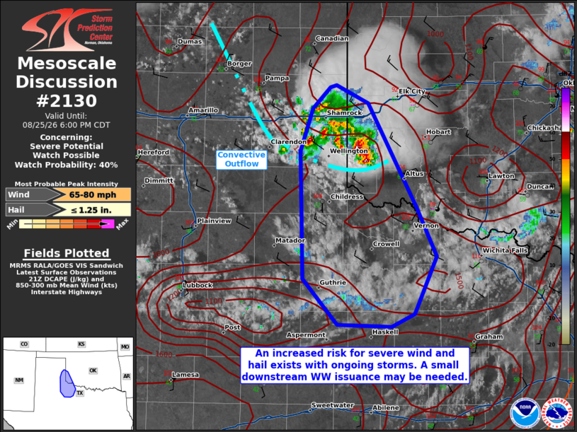
   SUMMARY...A few of the stronger storms may continue to produce
   severe hail and perhaps severe gusts, especially if storms can
   progress further south into a deeper/dry airmass. Trends are being
   monitored closely for the need of a Severe Thunderstorm Watch
   issuance.

   DISCUSSION...A multicellular cluster continues to propagate
   southward, with a history of producing measured hail over 1 inch in
   diameter, with MRMS MESH indicating up to 2 inch diameter hail
   potentially falling. As these storms continue to propagate farther
   south, they will encounter an even drier/deeper boundary layer,
   which may foster enough evaporative cooling to generate a few severe
   gusts via dry microbursts. It is unclear how far south storms will
   progress given increasingly weaker downstream deep-layer shear and
   overall drier air. Convective trends will continue to be monitored
   for the need of a Severe Thunderstorm Watch issuance.

   ..Squitieri/Thompson.. 08/25/2026

   ...Please see www.spc.noaa.gov for graphic product...

   ATTN...WFO...OUN...SJT...LUB...AMA...

   LAT...LON   33690050 34890052 35290038 35500018 35520011 35359976
               34389921 33919898 33369923 33249949 33270011 33690050

   MOST PROBABLE PEAK WIND GUST...65-80 MPH
   MOST PROBABLE PEAK HAIL SIZE...UP TO 1.25 IN
|
|
|
Top/All Mesoscale Discussions/Forecast Products/Home |
|
Source link