

| Mesoscale Discussion 2122 | |
| < Previous MD | |

|
|
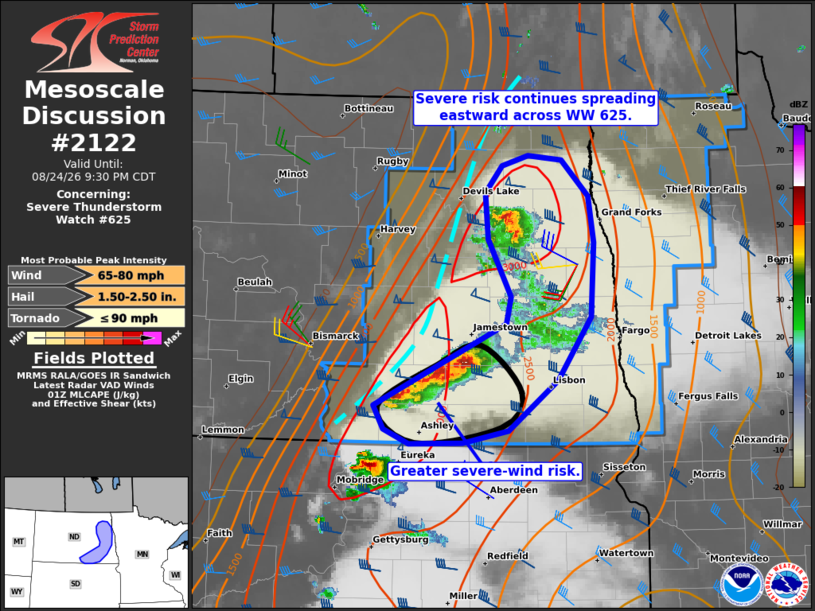
Mesoscale Discussion 2122 NWS Storm Prediction Center Norman OK 0831 PM CDT Mon Aug 24 2026 Areas affected...Parts of eastern North Dakota Concerning...Severe Thunderstorm Watch 625... Valid 250131Z - 250230Z The severe weather threat for Severe Thunderstorm Watch 625 continues. SUMMARY...The risk of large hail and damaging wind gusts continues spreading eastward across parts of eastern North Dakota -- within Severe Thunderstorm Watch 625. DISCUSSION...Following several storm splits and associated mergers, a small upscale-growing cluster has evolved along the surface front in south-central/southeast ND. Over the next couple hours, this cluster will continue southeastward and pose the greatest risk of damaging wind gusts -- given the well-established cold pool and strong surface-based buoyancy downstream. Additionally, left-movers evolving northeastward in north-central SD could interact with this cluster and result in additional upscale growth. However, the 00Z ABR sounding sampled robust low-level inhibition at the base of the EML, which may limit the severe risk with southeastward extent into parts of northeastern SD. Farther north, a separate convective cluster/left-mover is tracking northeastward across parts of northeastern ND. Around 45 kt of 0-6 km shear (per MVX VWP data) oriented perpendicular to the surface front and moderate surface-based buoyancy should help maintain this cluster for the next hour or two. Large hail and damaging winds will be the main concern with this activity. ..Weinman.. 08/25/2026 ...Please see www.spc.noaa.gov for graphic product... ATTN...WFO...FGF...ABR...BIS... LAT...LON 46279996 46999824 47249818 47759848 48159853 48399831 48499796 48459753 48139718 47719710 47059714 46499757 46049822 45949881 45929950 46069982 46279996 MOST PROBABLE PEAK TORNADO INTENSITY...UP TO 90 MPH MOST PROBABLE PEAK WIND GUST...65-80 MPH MOST PROBABLE PEAK HAIL SIZE...1.50-2.50 IN |
|
|
Top/All Mesoscale Discussions/Forecast Products/Home |
|
Source link