

| Mesoscale Discussion 2060 | |
| < Previous MD Next MD > | |
|
|
   Mesoscale Discussion 2060
   NWS Storm Prediction Center Norman OK
   0725 PM CDT Thu Aug 20 2026

   Areas affected...Parts of northern AL...Middle TN...and far
   northeast MS

   Concerning...Severe potential...Watch possible

   Valid 210025Z - 210300Z

   Probability of Watch Issuance...40 percent

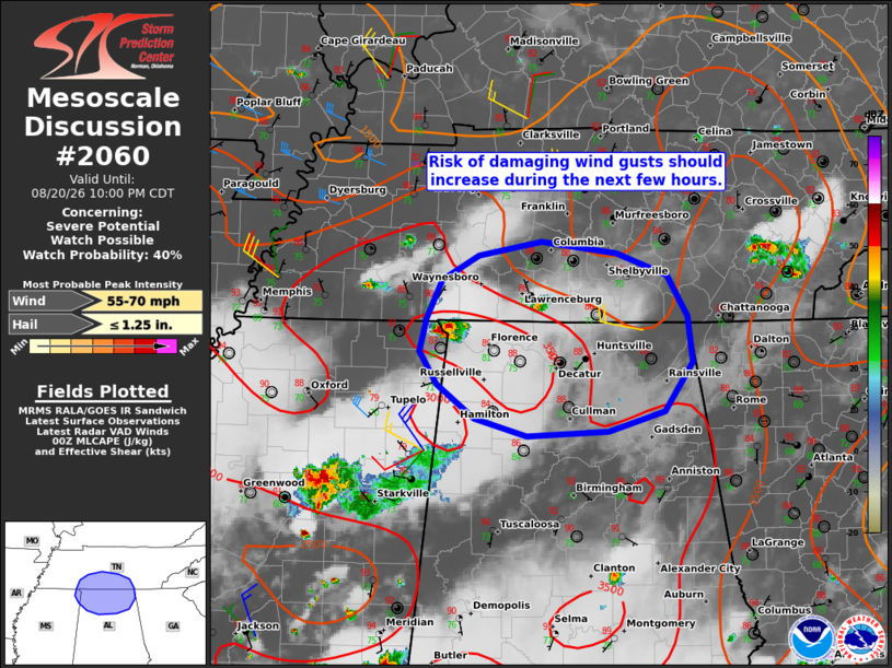
   SUMMARY...The risk of damaging wind gusts should increase over the
   next few hours. While a watch is not currently expected, trends will
   be monitored.

   DISCUSSION...Isolated thunderstorms are evolving within a zone of
   broad low-level confluence extending from parts of Middle/western TN
   into far northern MS. Over the next few hours, increasing
   large-scale ascent preceding a midlevel wave moving across the lower
   OH Valley could support an increase in thunderstorm coverage within
   this zone. Ahead of this activity, a warm and very moist PBL (upper
   70s to near 80 dewpoints) are yielding a corridor of strong
   surface-based buoyancy. While modest deep-layer flow/shear and lack
   of a LLJ should tend to limit convective organization, some
   strengthening of midlevel northwesterly flow accompanying the
   midlevel wave (sampled by upstream VWP) could favor a loosely
   organized cluster of storms. If this evolution occurs, damaging wind
   gusts will be the primary concern. While a gradual increase in
   nocturnal static stability and the modest deep-layer shear may
   temper the overall severe risk, convective trends will be monitored.

   ..Weinman/Guyer.. 08/21/2026

   ...Please see www.spc.noaa.gov for graphic product...

   ATTN...WFO...MRX...OHX...BMX...HUN...MEG...

   LAT...LON   34468820 34748839 35028832 35358815 35568778 35688713
               35588634 35398583 35038562 34648557 34228586 34058643
               34028727 34168781 34468820

   MOST PROBABLE PEAK WIND GUST...55-70 MPH
   MOST PROBABLE PEAK HAIL SIZE...UP TO 1.25 IN
|
|
|
Top/All Mesoscale Discussions/Forecast Products/Home |
|
Source link