

| Mesoscale Discussion 2050 | |
| < Previous MD | |

|
|
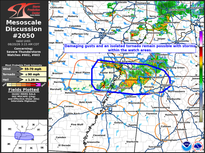
Mesoscale Discussion 2050 NWS Storm Prediction Center Norman OK 0149 AM CDT Thu Aug 20 2026 Areas affected...Southeast Missouri...southern Illinois...northern Arkansas...western Kentucky...western and Middle Tennessee Concerning...Severe Thunderstorm Watch 602...603... Valid 200649Z - 200815Z The severe weather threat for Severe Thunderstorm Watch 602, 603 continues. SUMMARY...The risk for damaging winds and an isolated tornado continues within the watch areas. A local watch extension in time may be needed as the scheduled expiration of Severe Thunderstorm Watch 602 at 3 am approaches. DISCUSSION...Strong/severe thunderstorms continue in a west-east zone within a region of modest warm advection at 0645z. Earlier reports of measured severe gusts and damage have been received across western Kentucky. Latest mesoanalysis depicted moderate/strong elevated buoyancy and 35-45 kts of westerly effective shear, supporting continued updraft organization and severe potential. In the near-term, the increase in storm coverage observed on regional radars and related convective overturning should result in the severe potential focusing on southern portions of WW 602, while continuing across WW 603. A local watch extension in time may ultimately be necessary across southern portions of WW 602 prior to the scheduled 3 am CDT expiration. ..Bunting/Mosier.. 08/20/2026 ...Please see www.spc.noaa.gov for graphic product... ATTN...WFO...LMK...OHX...PAH...MEG...LSX...LZK... LAT...LON 37449049 37308893 37248756 36938656 36588622 36178620 35908666 35828754 35818832 35908935 35929012 36039062 36279083 37009084 37449049 MOST PROBABLE PEAK TORNADO INTENSITY...UP TO 90 MPH MOST PROBABLE PEAK WIND GUST...55-70 MPH MOST PROBABLE PEAK HAIL SIZE...UP TO 1.25 IN |
|
|
Top/All Mesoscale Discussions/Forecast Products/Home |
|
Source link