

| Mesoscale Discussion 2049 | |
| < Previous MD | |

|
|
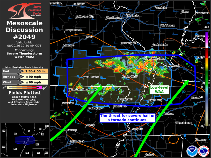
Mesoscale Discussion 2049 NWS Storm Prediction Center Norman OK 1104 PM CDT Wed Aug 19 2026 Areas affected...portions of southern Missouri into far northern Arkansas...far southern Illinois...western Kentucky...northwestern Tennessee Concerning...Severe Thunderstorm Watch 602... Valid 200404Z - 200530Z The severe weather threat for Severe Thunderstorm Watch 602 continues. SUMMARY...Scattered thunderstorms should continue to pose a severe hail threat for several more hours. A tornado also cannot be ruled out with cells on the southern periphery of the ongoing thunderstorm cluster. DISCUSSION...A multicellular cluster, with occasional transient supercells, continues to progress eastward over southern MO into far northern AR and far southern IL. MRMS MESH continues to indicate possible brief instances of severe hail accompanying some of the stronger storms within this cluster. Given the intensification of a low-level jet atop a decouple boundary layer, elevated buoyancy should continue to be advected to and ahead of the cluster, yielding 2000-3000 J/kg MUCAPE amid 40-50 kts of effective bulk shear. As such, the threat for severe hail will continue with the stronger storms. While these storms should remain largely elevated, a cell or two could manage to become surface based over the next hour or so and pose a sparse tornado risk. However, this scenario appears far less likely than that for elevated, severe-hail-producing storms. Elevated buoyancy continues to be advected into the TN Valley area, so an eastward extension of Severe Thunderstorm Watch 602 may be needed. ..Squitieri.. 08/20/2026 ...Please see www.spc.noaa.gov for graphic product... ATTN...WFO...OHX...PAH...MEG...LSX...LZK...SGF... LAT...LON 37319247 37468992 37458822 37088758 36358757 35968817 35888935 35979099 36059187 36179241 37319247 MOST PROBABLE PEAK TORNADO INTENSITY...UP TO 90 MPH MOST PROBABLE PEAK WIND GUST...UP TO 60 MPH MOST PROBABLE PEAK HAIL SIZE...1.50-2.50 IN |
|
|
Top/All Mesoscale Discussions/Forecast Products/Home |
|
Source link