

| Mesoscale Discussion 2048 | |
| < Previous MD | |
|
|
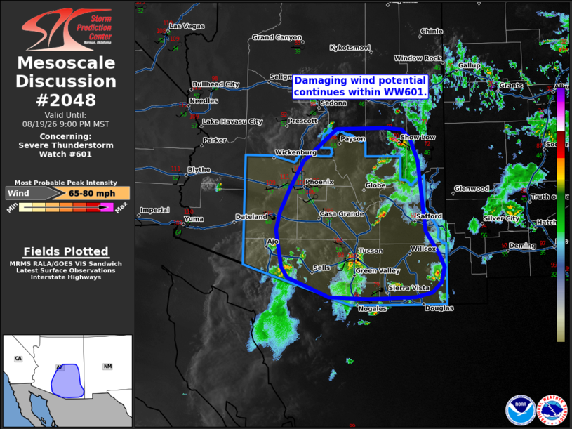
Mesoscale Discussion 2048 NWS Storm Prediction Center Norman OK 0900 PM CDT Wed Aug 19 2026 Areas affected...southern Arizona Concerning...Severe Thunderstorm Watch 601... Valid 200200Z - 200400Z The severe weather threat for Severe Thunderstorm Watch 601 continues. SUMMARY...Damaging wind potential continues within WW601. DISCUSSION...Several clusters of storms are ongoing across WW601 from Tuscon to just west of the White Mountains in Apache/Navajo County. A broad outflow boundary exists from central Apache County southward across Greenlee/Graham Counties. Surface observations have recorded gusts around 45 mph with this feature as it spreads west and south with occasional new development along its leading edge. It seems likely this feature will continue to move west and south this evening eventually moving into the Phoenix Metro. Additional outflow may also develop from the south near Tuscon. A recent observed gust around 57 mph was reported from the Tuscon Airport. The 00z sounding from PHX shows a deeply mixed profiles with very steep low-level lapse rates and moderate instability, with MLCAPE around 1700 J/kg. Additionally, temperatures are around 105-110 F. As storms continue along outflows moving into this hot and deeply mixed air mass, it is likely that the damaging wind potential will increase through the evening both along and ahead of the outflow and with additional thunderstorms. ..Thornton.. 08/20/2026 ...Please see www.spc.noaa.gov for graphic product... ATTN...WFO...TWC...FGZ...PSR... LAT...LON 33910963 34330980 34470997 34491008 34511029 34481136 33911208 33361238 32981257 32661265 32011252 31821240 31461152 31431070 31461006 31470969 31550935 31730915 31990909 32220919 32650948 33910963 MOST PROBABLE PEAK WIND GUST...65-80 MPH |
|
|
Top/All Mesoscale Discussions/Forecast Products/Home |
|
Source link