

| Mesoscale Discussion 1966 | |
| < Previous MD | |

|
|
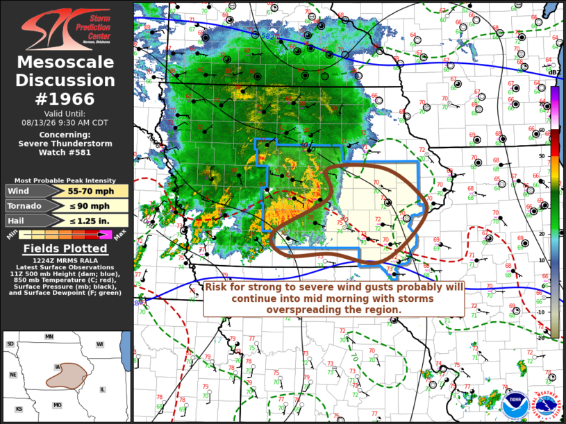
Mesoscale Discussion 1966 NWS Storm Prediction Center Norman OK 0727 AM CDT Thu Aug 13 2026 Areas affected...parts of central/southeastern Iowa and adjacent Illinois Concerning...Severe Thunderstorm Watch 581... Valid 131227Z - 131430Z The severe weather threat for Severe Thunderstorm Watch 581 continues. SUMMARY...The cluster of storms has undergone general weakening, but could still pose a risk for strong to severe wind gusts along and south of the I-80 corridor, east of Des Moines toward the Mississippi River, through 9-10 AM CDT. DISCUSSION...Coldest cloud tops in infrared satellite imagery and peak lightning flash rates have generally been maintained into the Des Moines vicinity, but the convective system has become less organized looking in radar loops. The primary MCV and westerly rear inflow to its southwest have undergone recent weakening. However, another notable cyclonic circulation has developed to the east-southeast (now to the northeast of Des Moines), within continuing stronger thunderstorm development focused near/above the leading edge of a developing area of 2-hourly surface pressure rises on the order of 2 mb. This may continue pose the most prominent risk for a swath of strong to severe surface gusts near the I-80 corridor east of Des Moines through 14-15Z. It does not appear out of the question that another similar circulation could still evolve within trailing convection now to the southwest through south of Des Moines. ..Kerr.. 08/13/2026 ...Please see www.spc.noaa.gov for graphic product... ATTN...WFO...DVN...DMX... LAT...LON 42189285 42199165 41779088 41429074 40889130 40659186 40809275 40769373 41139402 41709281 42189285 MOST PROBABLE PEAK TORNADO INTENSITY...UP TO 90 MPH MOST PROBABLE PEAK WIND GUST...55-70 MPH MOST PROBABLE PEAK HAIL SIZE...UP TO 1.25 IN |
|
|
Top/All Mesoscale Discussions/Forecast Products/Home |
|
Source link