

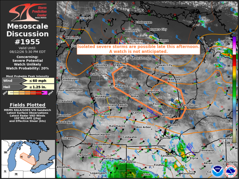
| Mesoscale Discussion 1955 | |
| < Previous MD | |

|
|
   Mesoscale Discussion 1955
   NWS Storm Prediction Center Norman OK
   0228 PM CDT Wed Aug 12 2026

   Areas affected...portions of central and eastern lower Michigan

   Concerning...Severe potential...Watch unlikely

   Valid 121928Z - 122130Z

   Probability of Watch Issuance...20 percent

   SUMMARY...Isolated severe storms capable of marginally severe hail
   and/or damaging wind gusts appear possible late this afternoon. A
   watch is not currently expected due to the limited areal coverage of
   the severe weather threat.

   DISCUSSION...Recent visible satellite imagery shows areas of
   deepening cumulus within a broadly confluent zone stretching through
   central lower MI, from KLDM to KD95. While multilevel clouds have
   slowed diabatic heating and resultant air mass destabilization,
   modification of the 15Z DTX sounding for current surface conditions
   yields MLCAPE of 1000-1500 J/kg. Water vapor imagery suggests that
   stronger forcing for ascent associated with a weak mid-level
   disturbance is currently shifting to the east of the region with
   low-level convergence and modest warm advection serving as the
   primary sources for widely scattered storm development by late
   afternoon. Additionally, surface observations and visible satellite
   suggest convective outflow from ongoing storms over IN and OH
   surging north, which may also focus storm development.

   Regional VWPs are sampling 40-50+ kt west-northwest winds generally
   above 4 km AGL, which are yielding sufficient deep-layer shear for
   some storm organization, including episodic supercell structures.
   Poor mid-level lapse rates of less than 7 C/km should limit hail
   sizes, though some marginally severe hail appears possible with the
   strongest storms. Damaging wind potential will be contingent on
   storms merging into clusters, leading to some cold pool
   organization.

   ..Mead/Thompson.. 08/12/2026

   ...Please see www.spc.noaa.gov for graphic product...

   ATTN...WFO...DTX...APX...GRR...

   LAT...LON   42588287 42928372 43608533 44068546 44388481 44088400
               43768301 43508243 42938221 42628243 42588287

   MOST PROBABLE PEAK WIND GUST...UP TO 60 MPH
   MOST PROBABLE PEAK HAIL SIZE...UP TO 1.25 IN
|
|
|
Top/All Mesoscale Discussions/Forecast Products/Home |
|
Source link