

| Mesoscale Discussion 1940 | |
| < Previous MD | |

|
|
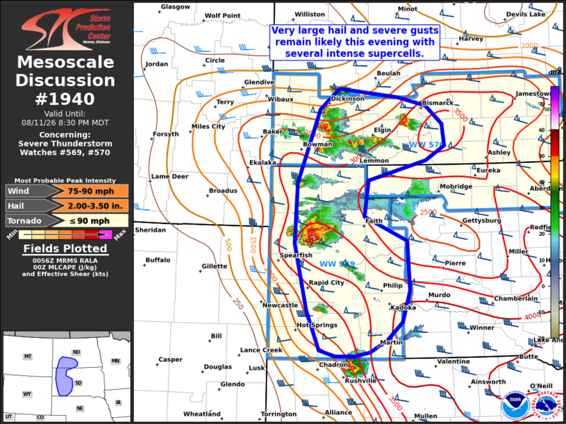
Mesoscale Discussion 1940 NWS Storm Prediction Center Norman OK 0758 PM CDT Tue Aug 11 2026 Areas affected...Parts of southwest/south-central ND into western SD Concerning...Severe Thunderstorm Watch 569...570... Valid 120058Z - 120230Z The severe weather threat for Severe Thunderstorm Watch 569, 570 continues. SUMMARY...Very large hail and severe gusts remain likely this evening with several ongoing supercells. DISCUSSION...Multiple intense supercells are present this evening across southwest ND and western SD. The 00Z observed sounding from UNR showed around 3500 J/kg of MLCAPE present to support these ongoing supercells, along with favorable deep layer shear of 45+ kt. Current expectations are that a threat for very large hail will continue this evening given the mainly discrete mode, presence of steep mid-level lapse rates, and favorable westerly shear vectors. The threat for severe gusts may also increase this evening, especially with an ongoing HP supercell transitioning to a small but intense bowing cluster with RFD surge evident in Butte/Meade Counties in western SD. This activity may tend to develop east-southeastward this evening into a very unstable airmass into parts of central SD, with 75+ mph gusts possible on an isolated basis. With Severe Thunderstorm Watch 569 in western SD scheduled to expire at 02Z, either a new watch or extension in time will likely be required within the next hour. ..Gleason/Mosier.. 08/12/2026 ...Please see www.spc.noaa.gov for graphic product... ATTN...WFO...ABR...BIS...UNR... LAT...LON 43110298 43730325 44740351 45660345 46780298 47090256 46970128 46840068 46560032 46220028 46010068 45710193 45150201 44790110 44020106 43540122 43260155 43090191 43020222 43020263 43110298 MOST PROBABLE PEAK TORNADO INTENSITY...UP TO 90 MPH MOST PROBABLE PEAK WIND GUST...75-90 MPH MOST PROBABLE PEAK HAIL SIZE...2.00-3.50 IN |
|
|
Top/All Mesoscale Discussions/Forecast Products/Home |
|
Source link