

| Mesoscale Discussion 1927 | |
| < Previous MD | |

|
|
   Mesoscale Discussion 1927
   NWS Storm Prediction Center Norman OK
   0104 PM CDT Tue Aug 11 2026

   Areas affected...portions of the central Appalachians into the NC/VA
   Piedmont

   Concerning...Severe potential...Watch unlikely

   Valid 111804Z - 112000Z

   Probability of Watch Issuance...20 percent

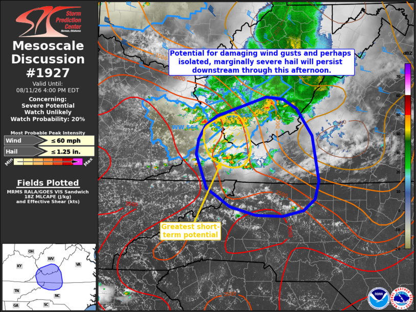
   SUMMARY...The threat for occasional damaging wind gusts and perhaps
   isolated marginally severe hail will expand downstream over the next
   several hours.

   DISCUSSION...An ongoing MCS currently extending across portions of
   southern West Virginia has largely waned in intensity over the past
   1-2 hours with modest cloud top warming noted via recent satellite
   imagery. In addition, a gradual transition toward a more
   outflow-dominant storm mode is likely ongoing as convection
   continues to encounter a more weakly sheared environment with
   southeastward extent (effective shear of 20 kts or less noted across
   western Virginia and northern North Carolina via latest objective
   analysis). Regardless, expectation is for this activity to continue
   south-southeastward through this afternoon along a surface buoyancy
   gradient. Modestly steeper low-level lapse rates noted downstream
   across the Piedmont should allow at least some potential for
   damaging wind gusts to continue, with the greatest potential likely
   to reside with the convection located along the aforementioned
   instability gradient. This threat is expected to remain generally
   isolated, however, owing to the more weakly sheared environment.
   Trends will continue to be monitored, but a downstream watch appears
   unlikely at this time.

   ..Chalmers/Hart.. 08/11/2026

   ...Please see www.spc.noaa.gov for graphic product...

   ATTN...WFO...RAH...RNK...RLX...GSP...MRX...JKL...

   LAT...LON   37588235 37748209 38088100 38048062 37878032 37397997
               36597984 36277993 36068017 35968063 35988122 36138179
               36478231 37078255 37338249 37588235

   MOST PROBABLE PEAK WIND GUST...UP TO 60 MPH
   MOST PROBABLE PEAK HAIL SIZE...UP TO 1.25 IN
|
|
|
Top/All Mesoscale Discussions/Forecast Products/Home |
|
Source link