

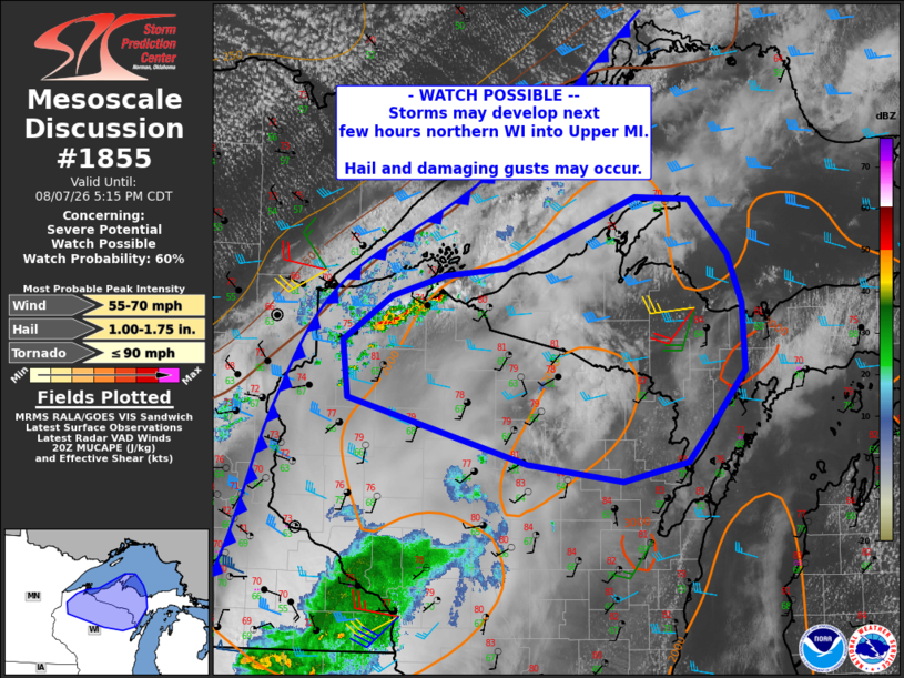
| Mesoscale Discussion 1855 | |
| < Previous MD | |

|
|
   Mesoscale Discussion 1855
   NWS Storm Prediction Center Norman OK
   0311 PM CDT Fri Aug 07 2026

   Areas affected...northern Wisconsin into Upper Michigan

   Concerning...Severe potential...Watch possible

   Valid 072011Z - 072215Z

   Probability of Watch Issuance...60 percent

   SUMMARY...Scattered storms may develop across northern Wisconsin and
   move into Upper Michigan later this afternoon. Large hail and
   damaging gusts will be possible.

   DISCUSSION...Visible imagery shows convection beginning to form
   along the cold front as it moves into far northern WI and toward
   southwestern parts of Lake Superior. While substantial high clouds
   have overspread the warm sector, areas of heating exist, with
   temperatures now into the low 80s F.

   A special 18Z GRB sounding confirms steep lapse rates above the
   capping inversion, with overall moderate instability. Deep-layer
   shear is a bit marginal for supercells, but near 30 kt. Overall,
   this setup should favor scattered cells/clusters, with periods of
   hail and gusty winds. A supercell or two could produce hail at or
   above golf ball size.

   ..Jewell/Gleason.. 08/07/2026

   ...Please see www.spc.noaa.gov for graphic product...

   ATTN...WFO...MQT...GRB...DLH...ARX...MPX...

   LAT...LON   47468761 46988713 46558695 45988692 45518733 45188763
               45008844 45168964 45739188 46239196 46619135 46809068
               46878993 47498829 47468761

   MOST PROBABLE PEAK TORNADO INTENSITY...UP TO 90 MPH
   MOST PROBABLE PEAK WIND GUST...55-70 MPH
   MOST PROBABLE PEAK HAIL SIZE...1.00-1.75 IN
|
|
|
Top/All Mesoscale Discussions/Forecast Products/Home |
|
Source link