

| Mesoscale Discussion 1799 | |
| < Previous MD | |

|
|
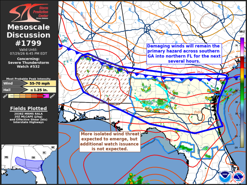
Mesoscale Discussion 1799 NWS Storm Prediction Center Norman OK 0340 PM CDT Wed Jul 29 2026 Areas affected...Southern Georgia into northern Florida Concerning...Severe Thunderstorm Watch 532... Valid 292040Z - 292245Z The severe weather threat for Severe Thunderstorm Watch 532 continues. SUMMARY...The potential for damaging wind, and perhaps brief instances of large hail, continues for portions of northern Georgia and southern Florida. DISCUSSION...Radar trends over the past hour depict mostly short-lived pulse convection and outflow-dominant clusters across southern GA. Although much of this activity has struggled to maintain intensity (mainly owing to the limited kinematic environment as sampled by regional VWPs), several instances of wind damage have been noted with the more robust convective cores and attendant downdrafts. Regionally, thermodynamic conditions remain supportive of intense updrafts (as evident by periodic bursts of colder cloud tops in GOES IR imagery and occasional MESH cores) with MLCAPE remaining near 2500-3000 J/kg and low-level lapse rates around 8 C/km away from the deeper convective cold pools. A combination of continued ascent along a weak front and along colliding outflow boundaries should continue to promote scattered, but relatively transient, convection capable of damaging wind swaths and perhaps brief instances of large hail (most likely near 1 inch). Further west into southern Alabama, thunderstorms are beginning to develop along the diffuse cold front and within a similar thermodynamic and kinematic environment. As with southern GA, storms developing across southern AL will most likely exhibit pulse-like behavior with some degree of clustering possible. Damaging downburst winds will be the primary hazard, though isolated instances of large hail will be possible with the more intense updraft pulses. Weaker frontal forcing should promote more isolated thunderstorm coverage. ..Moore.. 07/29/2026 ...Please see www.spc.noaa.gov for graphic product... ATTN...WFO...CHS...JAX...FFC...TAE...BMX...MOB... LAT...LON 30128117 29888235 30248425 31378709 31998744 32448747 32728722 32798695 32608640 32358552 32058297 32048125 31998093 31778092 31488109 31208124 30918134 30628136 30128117 MOST PROBABLE PEAK WIND GUST...55-70 MPH MOST PROBABLE PEAK HAIL SIZE...UP TO 1.25 IN |
|
|
Top/All Mesoscale Discussions/Forecast Products/Home |
|
Source link