

| Mesoscale Discussion 1766 | |
| < Previous MD | |

|
|
   Mesoscale Discussion 1766
   NWS Storm Prediction Center Norman OK
   0151 PM CDT Mon Jul 27 2026

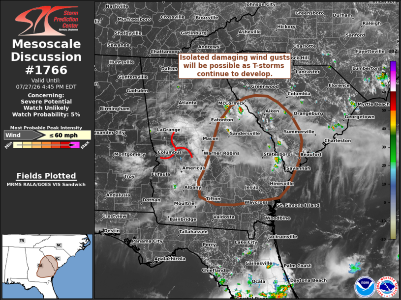
   Areas affected...Eastern Georgia into southeastern South Carolina

   Concerning...Severe potential...Watch unlikely

   Valid 271851Z - 272045Z

   Probability of Watch Issuance...5 percent

   SUMMARY...Thunderstorms developing across eastern Georgia and into
   adjacent portions of southeastern South Carolina may pose a damaging
   wind risk this afternoon. Watch issuance is not expected.

   DISCUSSION...Growing cumulus and the early stages of thunderstorm
   development are noted across portions of southeast GA into adjacent
   areas of SC. This activity comes as diurnal heating erodes
   inhibition head of a weak mid-level perturbation (the remnants of an
   early-morning MCS) that is approaching the region. Thunderstorm
   intensification and coverage should slowly increase as weak ascent
   ahead of the perturbation overspreads the region and daytime heating
   continues to bolster buoyancy (MLCAPE values are expected to reach
   around 3000-3500 J/kg). Very weak deep-layer wind shear will limit
   storm longevity and intensity, but steepening low-level lapse rates
   near 8.5 C/km will favor accelerating downdrafts and strong
   downburst with swaths of damaging winds (most likely peaking between
   40-60 mph). Given the poor kinematic environment and the isolated
   nature of the threat, watch issuance is not expected.

   ..Moore/Hart.. 07/27/2026

   ...Please see www.spc.noaa.gov for graphic product...

   ATTN...WFO...CHS...CAE...GSP...JAX...FFC...TAE...

   LAT...LON   31688100 31418127 31228265 31238318 31438365 31828371
               32068357 32738332 33368311 33538296 33768275 33838262
               33988231 34058200 34028162 33858128 33548089 33158064
               32868058 32358066 31688100

   MOST PROBABLE PEAK WIND GUST...UP TO 60 MPH
|
|
|
Top/All Mesoscale Discussions/Forecast Products/Home |
|
Source link