

| Mesoscale Discussion 1733 | |
| < Previous MD Next MD > | |

|
|
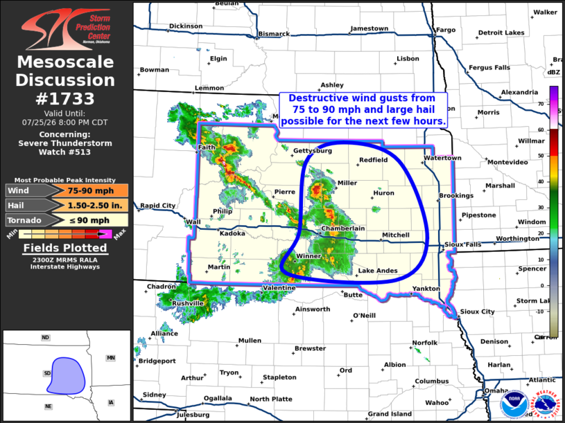
Mesoscale Discussion 1733 NWS Storm Prediction Center Norman OK 0602 PM CDT Sat Jul 25 2026 Areas affected...Eastern South Dakota Concerning...Severe Thunderstorm Watch 513... Valid 252302Z - 260100Z The severe weather threat for Severe Thunderstorm Watch 513 continues. SUMMARY...Destructive wind gusts from 75 to 90 mph and large hail are possible as the convective cluster across central South Dakota continues to intensify and grow upscale. DISCUSSION...A convective cluster continues to evolve across central South Dakota. This cluster is just now beginning to interact with a reservoir of ample low-level moisture in place across eastern/southeastern South Dakota. Recent surface analysis reveals numerous observations with dewpoints in the mid to upper 70s, with a few in far southeast South Dakota and far northeast Nebraska reporting dewpoints in the low 80s. This copious low-level moisture, in tandem with temperatures in the upper 90s/low 100s, is supporting extreme buoyancy, with mesoanalysis estimating over 3000 J/kg MLCAPE. General expectation is for this portion of the cluster to intensify as it continues eastward over the next several hours, potentially evolving into a significant wind-producing MCS over the next few hours. Primary hazard will be very strong, destructive wind gusts from 75 to 90 mph, with the strongest gusts more likely after 00Z. A discrete supercell continues to progress northeastward within the northern portion of the cluster over Hyde County South Dakota. Given its mature and organized character, expectation is for this supercell to persist for at least the next hour, with its motion potentially becoming more east-northeastward to eastward as it grows upscale. Large hail up to 2" in diameter and strong gusts over 75 mph are possible with this cell. ..Mosier.. 07/25/2026 ...Please see www.spc.noaa.gov for graphic product... ATTN...WFO...FSD...ABR...UNR... LAT...LON 43829976 44919964 45229884 44939762 43729703 43079771 43180002 43829976 MOST PROBABLE PEAK TORNADO INTENSITY...UP TO 90 MPH MOST PROBABLE PEAK WIND GUST...75-90 MPH MOST PROBABLE PEAK HAIL SIZE...1.50-2.50 IN |
|
|
Top/All Mesoscale Discussions/Forecast Products/Home |
|
Source link