

| Mesoscale Discussion 1732 | |
| < Previous MD | |

|
|
   Mesoscale Discussion 1732
   NWS Storm Prediction Center Norman OK
   0441 PM CDT Sat Jul 25 2026

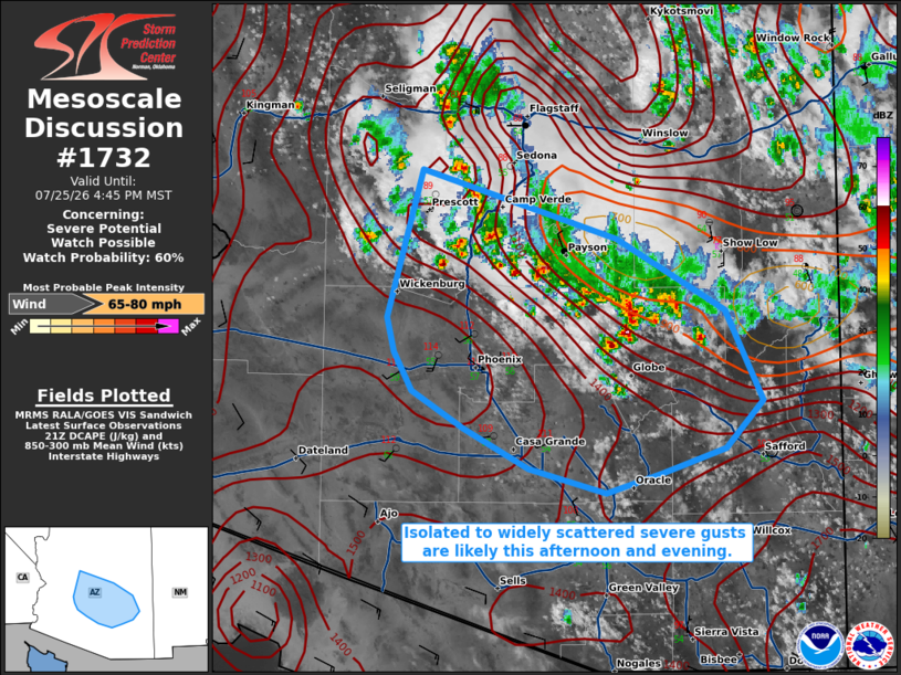
   Areas affected...portions of central Arizona

   Concerning...Severe potential...Watch possible

   Valid 252141Z - 252345Z

   Probability of Watch Issuance...60 percent

   SUMMARY...Multiple severe gusts may occur with embedded downbursts
   this afternoon and evening. A couple of gusts could exceed 75 mph.

   DISCUSSION...A cluster of multicells and pulse-cellular storms have
   gradually congealed into a loosely organized MCS, which is sagging
   south-southwestward off of the higher terrain. As the MCS and its
   cold pool propagates toward the lower terrain, it will overspread a
   hot and deeply mixed boundary layer. Surface temperatures over 110
   F, amid 50s F dewpoints, yields 1500-2000 J/kg DCAPE amid 50-60 F
   surface T/Td spreads, suggesting that ample evaporative cooling
   potential exists for embedded downbursts to produce potential
   several severe gusts. Given the magnitude of evaporative cooling
   potential present, 75+ mph gusts may occur. One or more haboobs may
   develop with this storm cluster and produce low-visibility
   conditions as well.

   ..Squitieri/Hart.. 07/25/2026

   ...Please see www.spc.noaa.gov for graphic product...

   ATTN...WFO...TWC...FGZ...PSR...

   LAT...LON   34811251 34331090 33831000 33210968 32881000 32711051
               32561099 32731162 33021217 33281259 33551275 33791281
               34811251

   MOST PROBABLE PEAK WIND GUST...65-80 MPH
|
|
|
Top/All Mesoscale Discussions/Forecast Products/Home |
|
Source link