

| Mesoscale Discussion 1728 | |
| < Previous MD | |

|
|
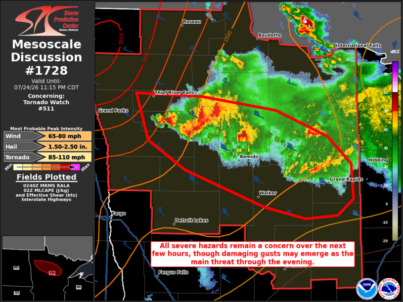
Mesoscale Discussion 1728 NWS Storm Prediction Center Norman OK 0943 PM CDT Fri Jul 24 2026 Areas affected...portions of northern Minnesota Concerning...Tornado Watch 511... Valid 250243Z - 250415Z The severe weather threat for Tornado Watch 511 continues. SUMMARY...Severe gusts may become the main threat over the next few hours as the remaining dominant storms congeal, though a tornado or instance of severe hail cannot be ruled out. DISCUSSION...Multiple supercells continue to track along a diffuse baroclinic zone at the terminus of a low-level warm-air advection regime, with a recent history of severe hail and a reported tornado. However, both KMVX and MRMS mosaic radar imagery depict the remaining mature supercells to be clustering, perhaps growing upscale into a cold-pool-driven MCS. All severe hazards will remain in place for a few more hours with supercell structures (given residual 1000+ J/kg MLCAPE and 40 kts of effective bulk shear per 02Z mesoanalysis). However, if an MCS materializes, severe gusts will become the primary hazard. Either way, the current thinking is that nocturnal cooling and increased MLCINH will ultimately weaken the storms and limit the severe threat in a few hours. ..Squitieri.. 07/25/2026 ...Please see www.spc.noaa.gov for graphic product... ATTN...WFO...DLH...FGF... LAT...LON 48159643 48119544 47979431 47719353 47429319 47079315 46899340 46879387 46989448 47199514 47379568 47669625 48159643 MOST PROBABLE PEAK TORNADO INTENSITY...85-110 MPH MOST PROBABLE PEAK WIND GUST...65-80 MPH MOST PROBABLE PEAK HAIL SIZE...1.50-2.50 IN |
|
|
Top/All Mesoscale Discussions/Forecast Products/Home |
|
Source link