

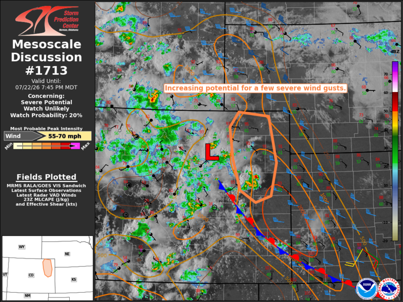
| Mesoscale Discussion 1713 | |
| < Previous MD | |

|
|
   Mesoscale Discussion 1713
   NWS Storm Prediction Center Norman OK
   0643 PM CDT Wed Jul 22 2026

   Areas affected...northeast Colorado

   Concerning...Severe potential...Watch unlikely

   Valid 222343Z - 230145Z

   Probability of Watch Issuance...20 percent

   SUMMARY...The potential for a few severe wind gusts is expected to
   increase across the discussion area this evening. The areal coverage
   of the threat is expected to remain too limited to warrant a watch
   issuance.

   DISCUSSION...Recent radar trends indicate thunderstorms gradually
   increasing in areal coverage across portions of Lincoln and Kit
   Carson Counties, to the north of a stalled front. The storms are
   developing within the western edge of a more moist and unstable
   boundary layer (i.e., MLCAPE up to 1000-2000 J/kg), and within a
   zone of stronger east to southeast surface winds. Aided by a gust
   front approaching from the west, latest CAM guidance suggests the
   potential for upscale growth into a loosely organized complex or
   line by 01-02Z.

   The current KGLD VWP is sampling a 1-km deep layer of southeast
   winds, which will enhance storm-relative inflow into the developing
   storms. When coupled with steep low/mid-level lapse rates and
   boundary-layer temperature-dewpoint spreads of 30+ degrees, the
   setup appears supportive of a few severe wind gusts this evening.

   ..Mead/Mosier.. 07/22/2026

   ...Please see www.spc.noaa.gov for graphic product...

   ATTN...WFO...GLD...BOU...

   LAT...LON   39160355 39870376 40620387 40970359 40870269 39790245
               39030262 38870309 39160355

   MOST PROBABLE PEAK WIND GUST...55-70 MPH
|
|
|
Top/All Mesoscale Discussions/Forecast Products/Home |
|
Source link