

| Mesoscale Discussion 1682 | |
| < Previous MD | |

|
|
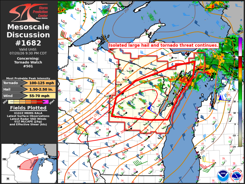
Mesoscale Discussion 1682 NWS Storm Prediction Center Norman OK 0804 PM CDT Mon Jul 20 2026 Areas affected...northeast Wisconsin into the central U.P. of Michigan Concerning...Tornado Watch 501... Valid 210104Z - 210230Z The severe weather threat for Tornado Watch 501 continues. SUMMARY...The threat for a couple tornadoes and large hail continues across the watch area. DISCUSSION...Widely scattered to scattered thunderstorms are ongoing as of 01Z with recent funnel cloud reports with discrete storms over Marathon County, WI. The 00Z Green Bay soundings sampled a steep lapse rate and moderately unstable air mass with MLCAPE in excess of 1500 J/kg. However, some degree of capping was observed in the 800-700 mb layer, which may be inhibiting storms from fully realizing the available instability. Latest objective fields suggest that 0-3 km CAPE may be larger in the vicinity of the front (and recent funnel cloud reports), where low-level parcel accelerations may be stronger. Per the Green Bay observed sounding and current VWP, vertical shear remains quite favorable for supercell modes with an attendant large hail and tornado risk. Despite modestly strong low-level storm-relative inflow, the spatial dimensions of the current storms are small, suggesting that perhaps the aforementioned capping may be diluting parcel buoyancy. As such, the extent of the tornado threat remains uncertain. Large hail will also remain possible with the strongest storms. ..Mead.. 07/21/2026 ...Please see www.spc.noaa.gov for graphic product... ATTN...WFO...MQT...GRB... LAT...LON 44429019 45049000 45598912 45968772 46108722 46228632 45738643 45098712 44328763 44328846 44429019 MOST PROBABLE PEAK TORNADO INTENSITY...100-125 MPH MOST PROBABLE PEAK WIND GUST...55-70 MPH MOST PROBABLE PEAK HAIL SIZE...1.50-2.50 IN |
|
|
Top/All Mesoscale Discussions/Forecast Products/Home |
|
Source link