

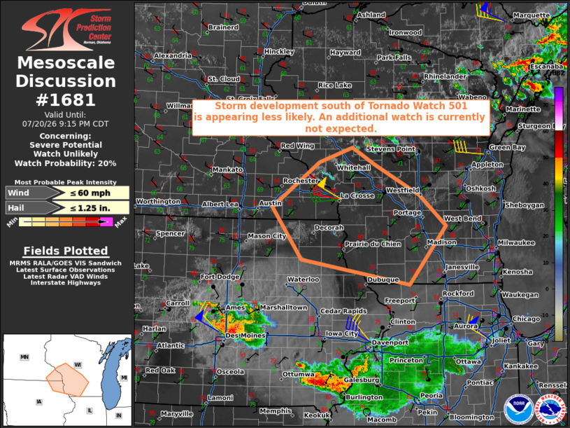
| Mesoscale Discussion 1681 | |
| < Previous MD | |

|
|
   Mesoscale Discussion 1681
   NWS Storm Prediction Center Norman OK
   0720 PM CDT Mon Jul 20 2026

   Areas affected...southwest Wisconsin...far southeast Minnesota...and
   northeast Iowa

   Concerning...Severe potential...Watch unlikely

   Valid 210020Z - 210215Z

   Probability of Watch Issuance...20 percent

   SUMMARY...Storm development south of Tornado Watch 501 is appearing
   less likely. Based on current observations, an additional watch is
   not expected.

   DISCUSSION...Over the past hour, visible satellite and radar data
   have shown several attempts at storm initiation along a weakly
   convergent surface front. Short parcel residence time within the
   frontal zone coupled with a warm nose in the 700-800 mb layer, per
   00Z MPX sounding, appears to limiting storm development. In
   addition, convectively processed air spreading north into the area
   from ongoing storms across IA is resulting in an increasingly narrow
   warm sector ahead of the front. Given these observations and the
   absence of storms in latest CAM guidance, an additional watch is not
   currently expected to the south of Tornado Watch 501.

   ..Mead.. 07/21/2026

   ...Please see www.spc.noaa.gov for graphic product...

   ATTN...WFO...GRB...MKX...DVN...ARX...MPX...

   LAT...LON   43699265 44399165 44619095 44369048 43878951 43398895
               42488974 42889202 43699265

   MOST PROBABLE PEAK WIND GUST...UP TO 60 MPH
   MOST PROBABLE PEAK HAIL SIZE...UP TO 1.25 IN
|
|
|
Top/All Mesoscale Discussions/Forecast Products/Home |
|
Source link