

| Mesoscale Discussion 1669 | |
| < Previous MD | |

|
|
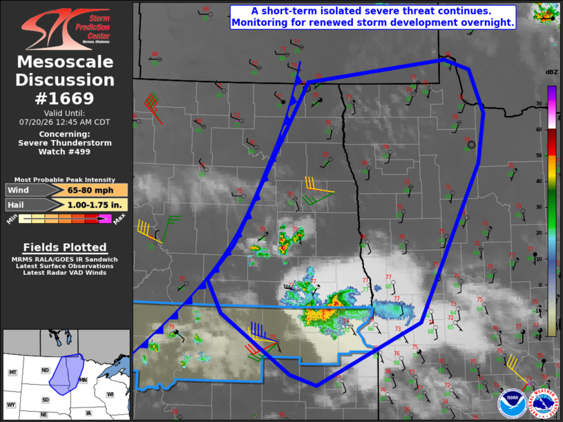
Mesoscale Discussion 1669 NWS Storm Prediction Center Norman OK 1142 PM CDT Sun Jul 19 2026 Areas affected...Eastern ND/northeast SD into west-central/northwest MN Concerning...Severe Thunderstorm Watch 499... Valid 200442Z - 200545Z The severe weather threat for Severe Thunderstorm Watch 499 continues. SUMMARY...A short-term threat for isolated severe hail/wind may spread across far northeast South Dakota into west-central Minnesota. Additional strong to severe storm development is possible into the overnight into eastern North Dakota and northwest Minnesota, though coverage and timing remains very uncertain. DISCUSSION...A persistent and occasionally severe storm cluster is approaching the northeast corner of SD as of 0440 UTC. In the short term, moderate elevated buoyancy and favorable effective shear (as observed earlier in the prefrontal 00Z soundings from BIS and ABR) will continue to support some severe wind/hail threat. Longevity of this cluster is uncertain due to increasing CINH and generally modest large-scale ascent, but some severe threat could accompany this cluster as it moves into west-central MN during the early overnight hours. Farther north, a conditionally favorable environment remains in place across eastern ND into far northwest MN, along/ahead of a cold front. Short-term guidance continues to vary considerably regarding the timing and coverage (if any) of elevated storm development in this area into the overnight hours. Should sustained storms develop within this region, MUCAPE of 2000-3000 J/kg and favorable deep-layer shear would support a threat for severe wind and hail. With generally weak ascent and only a modest low-level jet response anticipated, potential for more than isolated strong to severe storm development overnight remains very uncertain. However, watch issuance will become possible if trends support development of multiple severe storms. ..Dean/Hart.. 07/20/2026 ...Please see www.spc.noaa.gov for graphic product... ATTN...WFO...DLH...MPX...FGF...ABR...BIS... LAT...LON 45729560 44859765 44999818 45839955 46289982 46779932 49029787 49119698 49329505 49189453 48579426 47909438 45729560 MOST PROBABLE PEAK WIND GUST...65-80 MPH MOST PROBABLE PEAK HAIL SIZE...1.00-1.75 IN |
|
|
Top/All Mesoscale Discussions/Forecast Products/Home |
|
Source link