

| Mesoscale Discussion 1663 | |
| < Previous MD | |

|
|
   Mesoscale Discussion 1663
   NWS Storm Prediction Center Norman OK
   0355 PM CDT Sun Jul 19 2026

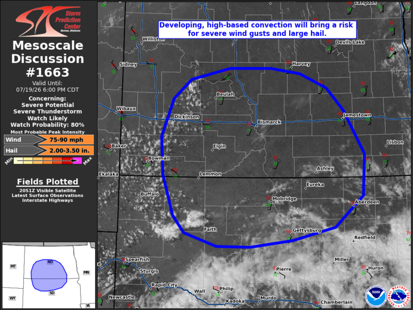
   Areas affected...portions of southern North Dakota into northern
   South Dakota

   Concerning...Severe potential...Severe Thunderstorm Watch likely

   Valid 192055Z - 192300Z

   Probability of Watch Issuance...80 percent

   SUMMARY...Developing, high-based convection will evolve eastward
   through this evening, bringing a risk for severe wind gusts (some
   potentially significant) and large hail, perhaps to 2-3+ inches in
   diameter.

   DISCUSSION...A developing cumulus field across far southwestern
   ND/northwestern SD has shown some signs of increased vertical growth
   over the past hour, with isolated thunderstorms noted across Perkins
   and Meade Counties in South Dakota as of 2050 UTC. Additional
   development is expected amid continued insolation and along a
   southeastward-progressing cold front over the next couple of hours.
   A modified 18z BIS sounding indicates steep low- and mid-level lapse
   rates are in place across this region along with around 30 kts of
   effective shear and relatively straight, elongated hodographs.
   Coupled with strengthening upper-level flow and further hodograph
   elongation with time, this environment will be supportive of
   initial, high-based splitting supercells capable of large hail
   (potentially to 2-3+ inches in diameter) and severe outflow wind
   gusts to 80+ mph. Efficient evaporative cooling will favor cold pool
   development, with upscale growth into one or more clusters (and a
   transition towards severe wind gusts as the primary threat) then
   expected as convection spreads eastward with time. A Severe
   Thunderstorm Watch will likely be needed later this afternoon to
   cover this severe potential.

   ..Chalmers/Thompson.. 07/19/2026

   ...Please see www.spc.noaa.gov for graphic product...

   ATTN...WFO...FGF...ABR...BIS...UNR...

   LAT...LON   46600306 47240277 47560236 47740141 47750043 47659973
               47419909 47049869 46319820 45639824 45119891 44899991
               44790092 44800171 45010249 45300275 45970300 46600306

   MOST PROBABLE PEAK WIND GUST...75-90 MPH
   MOST PROBABLE PEAK HAIL SIZE...2.00-3.50 IN
|
|
|
Top/All Mesoscale Discussions/Forecast Products/Home |
|
Source link