

| Mesoscale Discussion 1647 | |
| < Previous MD Next MD > | |

|
|
   Mesoscale Discussion 1647
   NWS Storm Prediction Center Norman OK
   1137 AM CDT Sat Jul 18 2026

   Areas affected...Southern Michigan into northeast
   Illinois...northern Indiana...and northwest Ohio

   Concerning...Severe potential...Watch possible

   Valid 181637Z - 181830Z

   Probability of Watch Issuance...60 percent

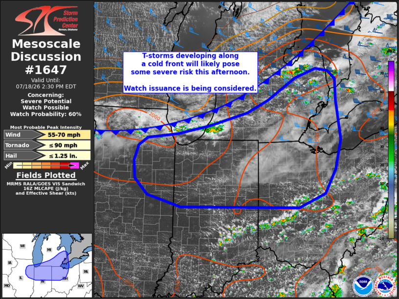
   SUMMARY...Thunderstorms developing along a cold front will continue
   to intensify and pose a risk for large hail and severe winds through
   the afternoon across portions of the Great Lakes/Midwest. Watch
   issuance is being considered and may be needed within the hour.

   DISCUSSION...Latest radar mosaics and GOES imagery shows maturing
   convection along and just ahead of a southeastward moving cold front
   with a few deeper, more robust updrafts noted across eastern lower
   MI and southwest lower MI. Downstream of this developing convection,
   temperatures continue to warm into the 80s within a moist air mass.
   With further diurnal heating expected through late afternoon, MLCIN
   will continue to erode as MLCAPE increases into the 2500-3000 J/kg
   range. Additionally, regional VWPs are sampling 35-40 knot mid-level
   flow over MI/OH with decreasing winds with westward extent. This
   flow should remain in place through the day as a mid-level wave
   continues to progress east/southeast towards the lower Great Lakes.

   Given these convective and environmental trends, the expectation is
   for additional thunderstorm development through the next few hours
   with a steady uptick in intensification. Sufficient deep-layer shear
   will promote organized storm modes, including the potential for a
   few supercells initially (especially across MI) before frontal
   ascent promotes increased clustering through late afternoon.
   Consequently, some hail threat will likely materialize before
   damaging/severe winds become the predominant threat through time
   across IN and OH. Convective trends are being monitored, and watch
   issuance will is probable as thunderstorm coverage continues to
   increase.

   ..Moore/Thompson.. 07/18/2026

   ...Please see www.spc.noaa.gov for graphic product...

   ATTN...WFO...CLE...ILN...DTX...IWX...GRR...IND...LOT...ILX...

   LAT...LON   40098729 40398838 40788880 41218885 41608871 41788841
               41898744 42108638 42438516 42748447 43278358 43518288
               43448249 43248225 42738223 41768210 41038228 40438264
               40088349 40098729

   MOST PROBABLE PEAK TORNADO INTENSITY...UP TO 90 MPH
   MOST PROBABLE PEAK WIND GUST...55-70 MPH
   MOST PROBABLE PEAK HAIL SIZE...UP TO 1.25 IN
|
|
|
Top/All Mesoscale Discussions/Forecast Products/Home |
|
Source link