

| Mesoscale Discussion 1643 | |
| < Previous MD | |

|
|
   Mesoscale Discussion 1643
   NWS Storm Prediction Center Norman OK
   0702 PM CDT Fri Jul 17 2026

   Areas affected...Parts of Upper Michigan...northern Wisconsin...and
   far east-central Minnesota

   Concerning...Severe potential...Watch unlikely

   Valid 180002Z - 180230Z

   Probability of Watch Issuance...20 percent

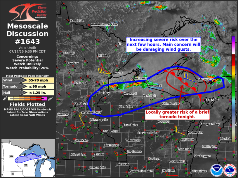
   SUMMARY...Severe risk will continue spreading east-southeastward
   into tonight. The primary concern will be damaging wind gusts.

   DISCUSSION...An east/west-oriented cluster of thunderstorms is
   tracking southeastward across far northwestern WI, generally focused
   along a cold front and associated surface wind shift. A deeply mixed
   PBL downstream may continue to promote outflow dominant storm
   structure, with the primary risk being locally damaging wind gusts.
   However, around 30-40 kt of line-orthogonal effective shear could
   support embedded supercell structures capable of severe gusts and
   isolated large hail as well.

   Over Upper MI, around 1500 J/kg MLCAPE and stronger deep-layer shear
   (around 50 kt of effective shear) will conditionally support
   supercell structures with any storms that spread/develop across the
   area tonight amid a gradually strengthening warm-advection plume.
   Additionally, the latest surface analysis shows a warm front draped
   across the area, and the MQT VWP is sampling a related
   clockwise-curved low-level hodograph. This boundary and related
   enhancement to the low-level shear/streamwise vorticity could
   provide a locally favorable corridor for storm organization and the
   potential for damaging winds, hail, and a brief tornado tonight.

   Current thinking is that the overall severe threat will remain too
   marginal and/or localized for a watch, though convective trends are
   being monitored -- especially over Upper MI where a locally greater
   severe risk is possible.

   ..Weinman/Hart.. 07/18/2026

   ...Please see www.spc.noaa.gov for graphic product...

   ATTN...WFO...MQT...GRB...DLH...MPX...

   LAT...LON   46589032 47048911 47128849 47048791 46878753 46648707
               46568667 46688626 46598601 46278596 46128661 46028788
               45918889 45279164 45199250 45299311 45659339 45969323
               46369254 46469192 46589032

   MOST PROBABLE PEAK TORNADO INTENSITY...UP TO 90 MPH
   MOST PROBABLE PEAK WIND GUST...55-70 MPH
   MOST PROBABLE PEAK HAIL SIZE...UP TO 1.25 IN
|
|
|
Top/All Mesoscale Discussions/Forecast Products/Home |
|
Source link