

| Mesoscale Discussion 1618 | |
| < Previous MD Next MD > | |

|
|
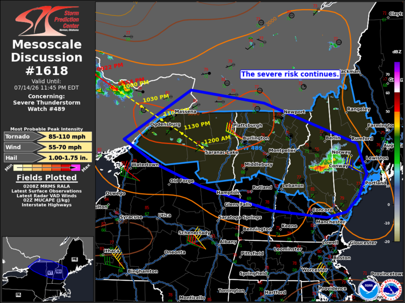
Mesoscale Discussion 1618 NWS Storm Prediction Center Norman OK 0911 PM CDT Tue Jul 14 2026 Areas affected...portions of northern New York into Vermont and New Hampshire Concerning...Severe Thunderstorm Watch 489... Valid 150211Z - 150345Z The severe weather threat for Severe Thunderstorm Watch 489 continues. SUMMARY...The severe risk continues over WW489. Additional supercells and organized clusters moving out of eastern Ontario will support a continued severe risk into the overnight hours. DISCUSSION...Across WW489, a cluster of severe storms has organized over portions of northern NH over the last couple of hours. These storms will continue to pose a risk for damaging gusts, hail and perhaps a tornado this evening as they move east/southeastward along a diffuse baroclinic zone in southern New England. Additional, more robust, convection was also noted in eastern ON this evening. The environment ahead of these severe storms remains strongly unstable (MUCAPE 3000+ J/kg) and sheared. High-res imagery from Canadian radars shows a mixed storm mode of supercells and organized clusters, which is likely to continue as they approach and cross the international border between 0300 and 0400 UTC. Given the favorable environment and storm mode, a continued risk for mainly hail and damaging winds is expected late this evening into the overnight hours. Though a tornado or two cannot be ruled out. ..Lyons.. 07/15/2026 ...Please see www.spc.noaa.gov for graphic product... ATTN...WFO...GYX...BTV...ALY...BUF... LAT...LON 44487608 45367446 45147266 44427040 43877018 43467039 43217069 43127117 43257247 43437322 43687421 44067530 44487608 MOST PROBABLE PEAK TORNADO INTENSITY...85-110 MPH MOST PROBABLE PEAK WIND GUST...55-70 MPH MOST PROBABLE PEAK HAIL SIZE...1.00-1.75 IN |
|
|
Top/All Mesoscale Discussions/Forecast Products/Home |
|
Source link