

| Mesoscale Discussion 1609 | |
| < Previous MD | |

|
|
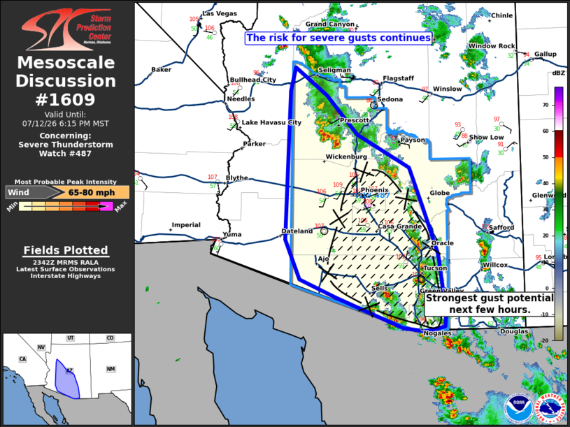
Mesoscale Discussion 1609 NWS Storm Prediction Center Norman OK 0643 PM CDT Sun Jul 12 2026 Areas affected...portions of central and southern Arizona Concerning...Severe Thunderstorm Watch 487... Valid 122343Z - 130115Z The severe weather threat for Severe Thunderstorm Watch 487 continues. SUMMARY...The potential for severe wind gusts continues this evening. The highest likelihood for strong gusts is expected to remain with the southern storm cluster this evening. DISCUSSION...As of 2340 UTC, regional radar and visible imagery showed several clusters of thunderstorms ongoing across portions of central and southern AZ. The environment ahead of these storms from the southern Mogollon Rim and adjacent desert remains unstable (SBCAPE 1000-2000 J/kg) and modestly sheared. Broader storm organization appears limited and contingent upon consolidating outflow. However, very warm surface temperatures and steep lapse rates in the low and mid-levels will favor the potential for severe gusts with high-based convection over the entire watch area this evening. The stronger of the storm clusters across the lower desert has shown some tendency to cluster over the last few hours and additional development has been noted east of the PHX Metro early this evening. Recent measured severe gusts at TUS and high-res guidance suggest this cluster will maintain the highest likelihood for severe gusts over the next few hours. ..Lyons.. 07/12/2026 ...Please see www.spc.noaa.gov for graphic product... ATTN...WFO...TWC...FGZ...PSR...VEF... LAT...LON 31841250 32121316 32731343 35071336 35441328 34991268 34381210 33871113 33241088 32511062 31601048 31371051 31301086 31351126 31841250 MOST PROBABLE PEAK WIND GUST...65-80 MPH |
|
|
Top/All Mesoscale Discussions/Forecast Products/Home |
|
Source link