

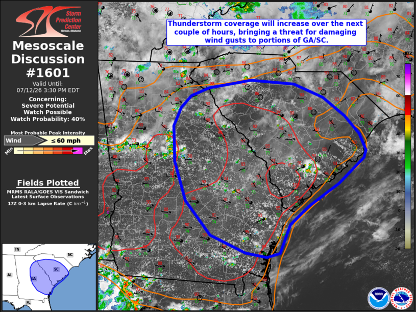
| Mesoscale Discussion 1601 | |
| < Previous MD | |

|
|
   Mesoscale Discussion 1601
   NWS Storm Prediction Center Norman OK
   1224 PM CDT Sun Jul 12 2026

   Areas affected...portions of eastern Georgia into much of South
   Carolina

   Concerning...Severe potential...Watch possible

   Valid 121724Z - 121930Z

   Probability of Watch Issuance...40 percent

   SUMMARY...Thunderstorm coverage will increase over the next 1-2
   hours across portions of Georgia and South Carolina, bringing a
   threat for damaging wind gusts. A Severe Thunderstorm Watch may
   eventually be needed.

   DISCUSSION...A hot, humid air mass remains in place across much of
   the Southeast, with temperatures noted to have already warmed into
   the low/mid 90s across portions of eastern Georgia and
   southern/central South Carolina as of 1720 UTC. Visible satellite
   imagery depicts increasingly agitated cumulus across the region,
   with developing thunderstorms noted south and east of the Atlanta
   Metro. Continued heating of this air mass will promote further
   destabilization through the afternoon to around 2000-3000 J/kg
   MLCAPE and increasing convective coverage over the next couple of
   hours. Weak deep-layer flow and effective shear suggest a relatively
   disorganized, outflow-dominant storm mode, but steepening low-level
   lapse rates and PW content near 2 inches will facilitate a risk for
   damaging wind gusts (with gusts up to around 60 mph possible) across
   the region. A Severe Thunderstorm Watch may be needed to cover this
   potential within the next 1-2 hours.

   ..Chalmers/Smith.. 07/12/2026

   ...Please see www.spc.noaa.gov for graphic product...

   ATTN...WFO...ILM...CHS...CAE...GSP...JAX...FFC...TAE...

   LAT...LON   31108148 31208198 31558281 32228339 33018366 33218367
               33718370 34098354 34338330 34488288 34648187 34578083
               34308014 33917962 33567927 33227913 33087918 32577979
               32128051 31768094 31188117 31108148

   MOST PROBABLE PEAK WIND GUST...UP TO 60 MPH
|
|
|
Top/All Mesoscale Discussions/Forecast Products/Home |
|
Source link