

| Mesoscale Discussion 1573 | |
| < Previous MD | |

|
|
   Mesoscale Discussion 1573
   NWS Storm Prediction Center Norman OK
   1210 PM CDT Fri Jul 10 2026

   Areas affected...portions of the middle Tennessee River Valley into
   northwestern Georgia

   Concerning...Severe potential...Watch unlikely

   Valid 101710Z - 101915Z

   Probability of Watch Issuance...20 percent

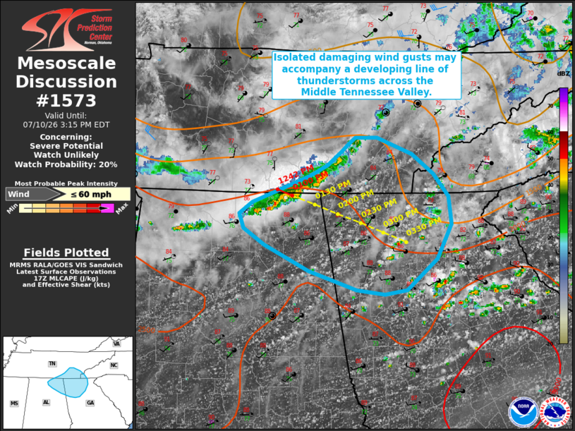
   SUMMARY...Isolated damaging wind gusts may accompany a developing
   band of thunderstorms over the next 1-2 hours. Watch issuance
   appears unlikely at this time.

   DISCUSSION...Regional radar imagery depicts a developing band of
   thunderstorms across the middle Tennessee River Valley as of 1710
   UTC, with recent radar imagery from KHTX sampling velocities
   approaching 50 kts at 500 ft AGL within a portion of this band.
   Aided by forcing for ascent and modestly enhanced mid-level flow
   along the southern/southeastern periphery of a remnant mid-level
   MCV, expectation is for this activity to progress east-southeastward
   amid a hot, humid, and destabilizing air mass. While weak effective
   shear (generally 25 kts or less per latest mesoanalysis) is likely
   to limit overall organization and should temper the severity of this
   convection, steepening low-level lapse rates will likely foster some
   increase in the risk for at least isolated damaging wind gusts over
   the next 1-2 hours. Trends will continue to be monitored, but watch
   issuance appears unlikely at this time.

   ..Chalmers/Smith.. 07/10/2026

   ...Please see www.spc.noaa.gov for graphic product...

   ATTN...WFO...MRX...FFC...BMX...HUN...

   LAT...LON   33818469 33868509 34098575 34388638 34578667 34748673
               34878654 35098600 35188573 35318549 35478530 35568519
               35628510 35638480 35438431 35218402 34948381 34628377
               34228396 33878438 33818469

   MOST PROBABLE PEAK WIND GUST...UP TO 60 MPH
|
|
|
Top/All Mesoscale Discussions/Forecast Products/Home |
|
Source link