

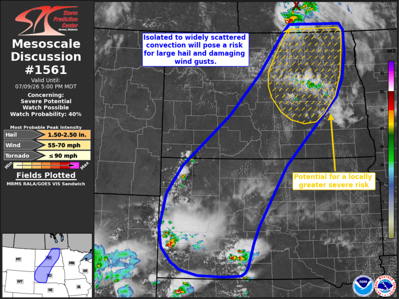
| Mesoscale Discussion 1561 | |
| < Previous MD | |

|
|
   Mesoscale Discussion 1561
   NWS Storm Prediction Center Norman OK
   0358 PM CDT Thu Jul 09 2026

   Areas affected...portions of western South Dakota into
   central/northeastern North Dakota

   Concerning...Severe potential...Watch possible

   Valid 092058Z - 092300Z

   Probability of Watch Issuance...40 percent

   SUMMARY...Isolated to widely scattered thunderstorms will bring a
   risk for large hail and damaging/severe wind gusts through this
   evening.

   DISCUSSION...Latest observations depict ongoing thunderstorms in
   close proximity to a convectively augmented shortwave trough noted
   over far southern Manitoba with developing, agitated cumulus also
   noted farther southwest over northwestern South Dakota. Aided by
   ascent ahead of this shortwave and weak convergence along a surface
   pre-frontal trough/weak wind shift, expectation is for ongoing
   thunderstorm activity to persist southeastward into North Dakota and
   for additional isolated to widely scattered thunderstorms to develop
   southwestward into western South Dakota. Moderate to strong buoyancy
   (up to 2500-3000 J/kg MLCAPE noted via latest mesoanalysis) and
   effective shear of 30-40 kts (as sampled by the 18z BIS observed
   sounding) will support supercells and a risk for large hail
   (including perhaps an isolated instance to around 2" in diameter)
   and damaging/severe wind gusts. Uncertainty remains regarding
   eventual thunderstorm and severe coverage, but a Severe Thunderstorm
   Watch may be needed for a portion of the discussion area to cover
   these threats should a corridor of greater severe potential become
   evident, such as across portions of central/eastern North Dakota
   where effective shear is modestly greater and where latest guidance
   suggests convective coverage may be greater.

   ..Chalmers/Thompson.. 07/09/2026

   ...Please see www.spc.noaa.gov for graphic product...

   ATTN...WFO...FGF...ABR...BIS...UNR...

   LAT...LON   44300060 43880080 43300099 43150108 43080123 43050180
               43070271 43210331 43410363 43760396 44230404 45070381
               45750329 46980165 47980060 49029970 49199950 49209808
               49199769 49049754 48479753 47879764 47419786 45759966
               44300060

   MOST PROBABLE PEAK TORNADO INTENSITY...UP TO 90 MPH
   MOST PROBABLE PEAK WIND GUST...55-70 MPH
   MOST PROBABLE PEAK HAIL SIZE...1.50-2.50 IN
|
|
|
Top/All Mesoscale Discussions/Forecast Products/Home |
|
Source link