

| Mesoscale Discussion 1560 | |
| < Previous MD Next MD > | |

|
|
   Mesoscale Discussion 1560
   NWS Storm Prediction Center Norman OK
   0353 PM CDT Thu Jul 09 2026

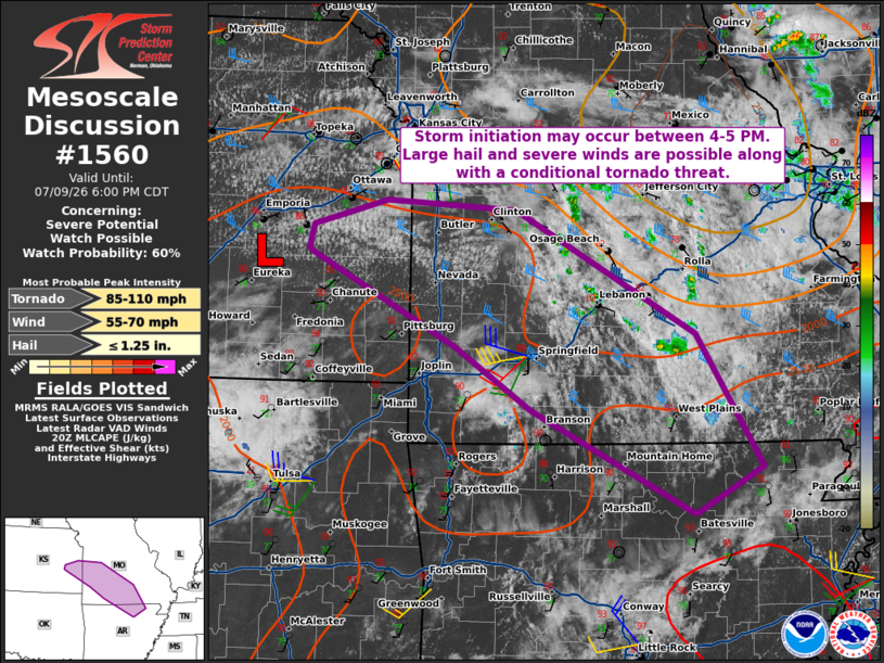
   Areas affected...Southeast Kansas into south-central Missouri and
   northern Arkansas

   Concerning...Severe potential...Watch possible

   Valid 092053Z - 092300Z

   Probability of Watch Issuance...60 percent

   SUMMARY...A watch is possible late this afternoon as storms form
   along an outflow/differential heating boundary. Shear is sufficient
   for marginal supercells capable of all hazards.

   DISCUSSION...Airmass recovery continues in the wake of an MCV that
   moved through Missouri earlier today. Temperatures to the southwest
   of the outflow/differential heating boundary have risen in the upper
   80s to low 90s F. Warm advection within this zone as well as near a
   weak surface low in southeast Kansas will eventually initiate a few
   thunderstorms. CAM guidance has generally suggested this will occur
   by 5 PM CDT or thereabouts. Enhanced shear from the MCV (30-35 kt
   effective shear) will promote marginal supercell structures. The
   primary hazards will be isolated large hail and damaging winds.
   Low-level flow is strong enough (see the KSGF VAD) to support
   rotating storms. Should supercells maintain intensity, a risk for a
   tornado could develop near the surface boundary.

   ..Wendt/Thompson.. 07/09/2026

   ...Please see www.spc.noaa.gov for graphic product...

   ATTN...WFO...PAH...LZK...SGF...EAX...TOP...ICT...

   LAT...LON   35929168 36789335 37309414 38079561 38119567 38319563
               38519485 38449350 37409164 36299095 35919162 35929168

   MOST PROBABLE PEAK TORNADO INTENSITY...85-110 MPH
   MOST PROBABLE PEAK WIND GUST...55-70 MPH
   MOST PROBABLE PEAK HAIL SIZE...UP TO 1.25 IN
|
|
|
Top/All Mesoscale Discussions/Forecast Products/Home |
|
Source link