

| Mesoscale Discussion 1542 | |
| < Previous MD Next MD > | |

|
|
   Mesoscale Discussion 1542
   NWS Storm Prediction Center Norman OK
   0203 PM CDT Wed Jul 08 2026

   Areas affected...portions of the central High Plains

   Concerning...Severe potential...Severe Thunderstorm Watch likely

   Valid 081903Z - 082100Z

   Probability of Watch Issuance...80 percent

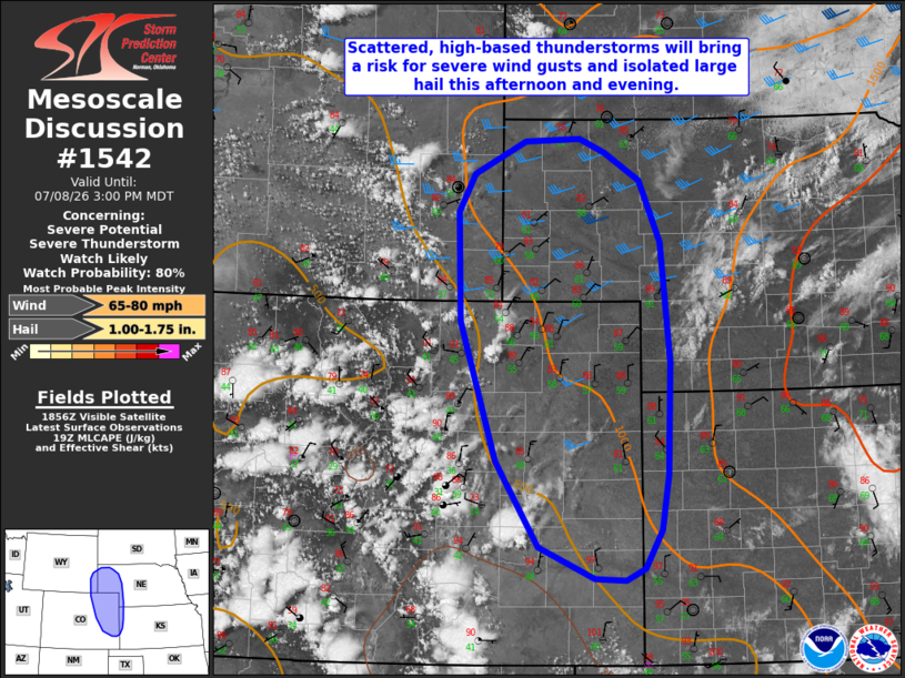
   SUMMARY...Scattered, high-based thunderstorms will bring a risk for
   severe wind gusts (with a couple of significant gusts possible) and
   isolated large hail this afternoon and evening. One or more Severe
   Thunderstorm Watches will likely be needed later this afternoon.

   DISCUSSION...Latest GOES visible satellite imagery depicts scattered
   thunderstorm development ongoing across the high-terrain from
   central Colorado northward into southeastern Wyoming. Aided by
   ascent ahead of a weak mid-level perturbation, continued heating and
   a modest upslope (easterly) wind component will continue to support
   the development of scattered, high-based thunderstorms through the
   afternoon. While moisture remains limited in the Colorado foothills
   (dewpoints in the 40s per latest surface analysis), deep-layer
   westerly flow will allow maturing convection to gradually interact
   with increasing moisture with eastward extent, which should promote
   gradual intensification with time.

   Steep low-level lapse rates (9+ C/km) and deep, well-mixed boundary
   layer profiles (LCLs of 2-3+ km) will promote efficient evaporative
   cooling and downward momentum transport, yielding a threat for
   primarily severe wind gusts (with a couple of significant wind gusts
   possible). Upscale growth into one or more linear clusters/segments
   is expected with time as cold pools gradually coalesce, yielding an
   increasing threat for severe wind gusts into this evening. With
   steep mid-level lapse rates in place, isolated large hail will also
   be possible (especially with any storms that are able to remain
   discrete) owing to modest strengthening of upper-level flow and
   elongation of hodographs with time. This potential will be locally
   greater farther to the north where better effective shear is already
   noted per latest mesoanalysis. One or more Severe Thunderstorm
   Watches will likely be needed in the next 1-2 hours to cover these
   threats.

   ..Chalmers/Hart.. 07/08/2026

   ...Please see www.spc.noaa.gov for graphic product...

   ATTN...WFO...LBF...DDC...GLD...PUB...BOU...CYS...

   LAT...LON   42760372 42780293 42630256 42330206 41640176 40330163
               39080166 38470177 38050201 37920228 37940272 38300351
               39230413 40770465 41970469 42400445 42760372

   MOST PROBABLE PEAK WIND GUST...65-80 MPH
   MOST PROBABLE PEAK HAIL SIZE...1.00-1.75 IN
|
|
|
Top/All Mesoscale Discussions/Forecast Products/Home |
|
Source link