

| Mesoscale Discussion 1523 | |
| < Previous MD | |

|
|
   Mesoscale Discussion 1523
   NWS Storm Prediction Center Norman OK
   0127 PM CDT Mon Jul 06 2026

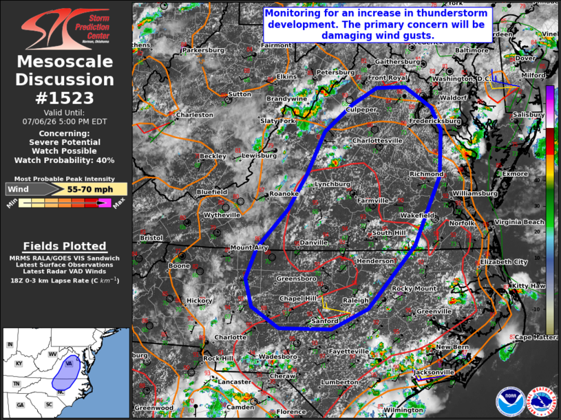
   Areas affected...Much of northern/central Virginia into
   north-central North Carolina

   Concerning...Severe potential...Watch possible

   Valid 061827Z - 062100Z

   Probability of Watch Issuance...40 percent

   SUMMARY...The area is being monitored for an increase in
   thunderstorm development this afternoon. The stronger storms will be
   capable of producing damaging wind gusts. It is unclear if a watch
   will be needed, especially in the near term.

   DISCUSSION...The latest radar data shows a gradual increase in
   thunderstorm development over the higher terrain of western VA ,
   with more isolated development farther east. Over the next few
   hours, continued diurnal heating and orographic lift should promote
   scattered thunderstorms. As these storms advance eastward into parts
   of central VA and north-central NC, steepening low-level lapse rates
   and increasing buoyancy will promote damaging wind gusts --
   especially with any clusters of storms that evolve. Current thinking
   is that the greater risk of damaging winds will develop later this
   afternoon into the evening, as storms congeal into small clusters.
   Therefore, the need for a watch is uncertain in the near term,
   though convective trends are being monitored.

   ..Weinman/Hart.. 07/06/2026

   ...Please see www.spc.noaa.gov for graphic product...

   ATTN...WFO...AKQ...LWX...RAH...RNK...

   LAT...LON   36578011 37117958 37627924 38217893 38617844 38837801
               38847750 38567704 38247687 37587689 36607735 35727817
               35427881 35437971 35738020 36138031 36578011

   MOST PROBABLE PEAK WIND GUST...55-70 MPH
|
|
|
Top/All Mesoscale Discussions/Forecast Products/Home |
|
Source link