

| Mesoscale Discussion 1503 | |
| < Previous MD | |

|
|
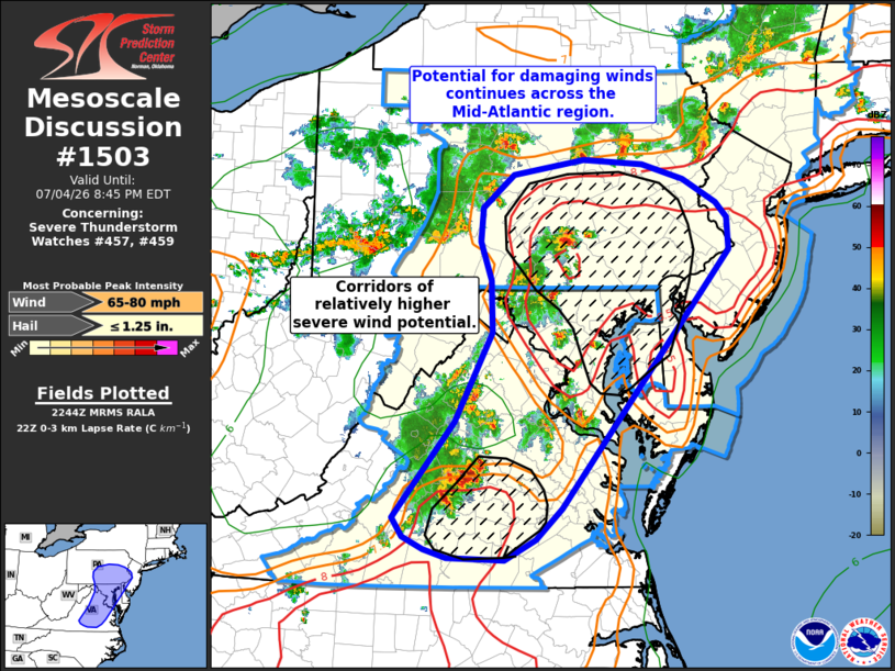
Mesoscale Discussion 1503 NWS Storm Prediction Center Norman OK 0547 PM CDT Sat Jul 04 2026 Areas affected...The Mid-Atlantic region Concerning...Severe Thunderstorm Watch 457...459... Valid 042247Z - 050045Z The severe weather threat for Severe Thunderstorm Watch 457, 459 continues. SUMMARY...The potential for damaging winds continues across the greater Mid-Atlantic region. More focused corridors of higher wind risk may emerge across southeastern Pennsylvania into northern Maryland and across parts of central Virginia over the next couple of hours. DISCUSSION...Regional radar mosaics continue to show multiple clusters of strong/severe thunderstorms with embedded swaths of stronger winds. Most wind reports so far have been in the 35-55 mph range, but occasional severe gusts and multiple reports of wind damage have been noted over the past hour. Regional VWPs continue to sample relatively weak deep-layer wind shear that will maintain outflow-dominant mutli-cell and clustered storm modes through late evening. However, surface temperatures remain fairly hot (upper 90s to low 100s) with steep low-level lapse rates noted across northern MD into southeastern PA, and across parts of central VA where convective overturning has yet to occur. For the next few hours, the expectation is for a continuation of poorly-organized multi-cell clusters with sporadic swaths of damaging/severe winds across much of the region. The wind risk will most likely be focused across central/southern VA where conditions remain very hot and across east/southeast PA where multiple clusters may converge and promote an uptick in thunderstorm coverage later this evening. ..Moore.. 07/04/2026 ...Please see www.spc.noaa.gov for graphic product... ATTN...WFO...PHI...BGM...AKQ...CTP...LWX...RNK... LAT...LON 37277934 38287852 39237802 39787805 40197820 40567816 40907774 41077678 41027598 40857542 40617497 40447482 40117480 37377708 37047742 36837785 36837820 36847861 36937893 37067920 37277934 MOST PROBABLE PEAK WIND GUST...65-80 MPH MOST PROBABLE PEAK HAIL SIZE...UP TO 1.25 IN |
|
|
Top/All Mesoscale Discussions/Forecast Products/Home |
|
Source link