| Mesoscale Discussion 1479 | |
| < Previous MD | |

|
|
Mesoscale Discussion 1479
NWS Storm Prediction Center Norman OK
0607 PM CDT Fri Jul 03 2026
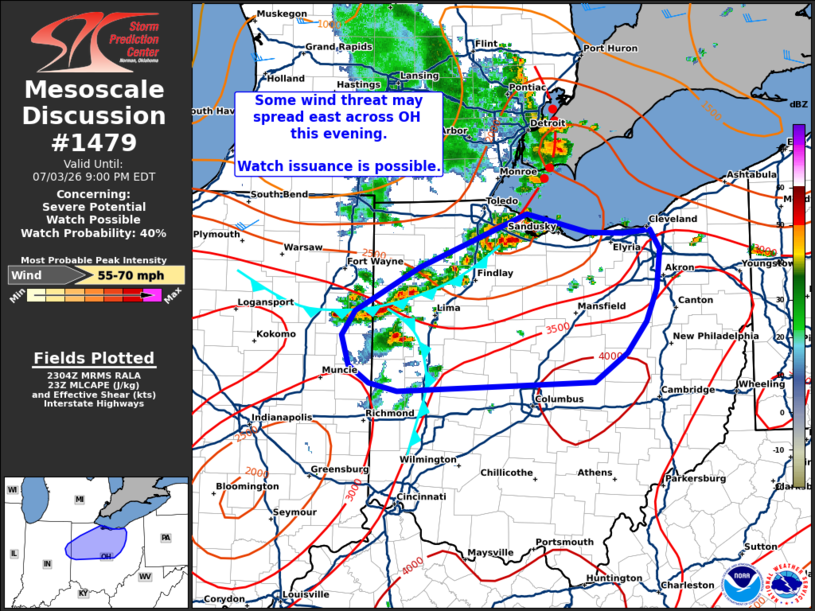
Areas affected...Northwest to north-central Ohio
Concerning...Severe potential...Watch possible
Valid 032307Z - 040100Z
Probability of Watch Issuance...40 percent
SUMMARY...Thunderstorm clusters may pose a threat for sporadic
damaging/severe winds over the next few hours. Trends will be
monitored, and watch issuance is possible if a more widespread
severe wind threat materializes.
DISCUSSION...Convection across eastern IN/western OH has been
monitored over the past hour or so and has exhibited
pulse/multi-cell behavior. More recently, convection has been
rapidly developing along the southern extent of the outflow
associated with the MCS that recently impacted the Detroit area.
This uptick in activity is likely attributable to the outflow
boundary impeding on a fairly buoyant and uninhibited air mass in
place across northwest to north-central OH. Further thunderstorm
development and clustering/upscale growth appears likely as the
outflow from the MCS and the cold pool from the west-central OH
cluster begin to interact and spread east.
Although ample buoyancy is noted downstream, regional VWPs show
decreasing mid-level flow with southward extent from MI into OH with
only around 15-20 knots of 0-6 km bulk shear observed across OH (as
compared to 25-35 knots further north in MI). Consequently, the
likelihood of the emergence of a well-organized MCS similar is
limited; however, the downstream environment should still support
strong to severe downburst winds over the next few hours before the
onset of nocturnal cooling. Based on the environmental parameter
space and output from recent high-res guidance, wind speeds will
most likely remain in the 50-65 mph range. Trends will continue to
be monitored, and watch issuance is possible if convection begins to
exceed these expectations.
..Moore/Gleason.. 07/03/2026
...Please see www.spc.noaa.gov for graphic product...
ATTN...WFO...PBZ...CLE...ILN...IWX...IND...
LAT...LON 40158483 40308506 40568515 40778500 41158427 41618305
41458235 41448196 41478166 41298155 40968158 40688171
40408193 40158230 40078452 40158483
MOST PROBABLE PEAK WIND GUST...55-70 MPH
|
|
|
Top/All Mesoscale Discussions/Forecast Products/Home |
|
Source link