| Mesoscale Discussion 1472 | |
| < Previous MD | |

|
|
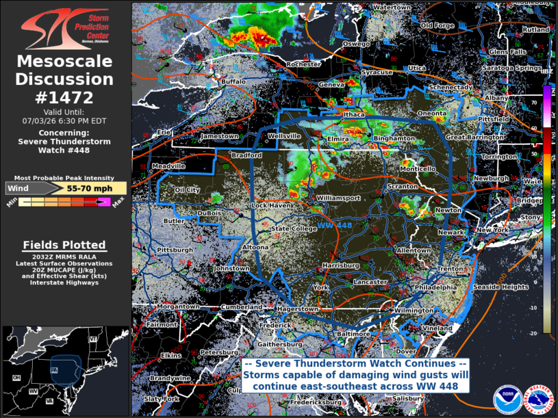
Mesoscale Discussion 1472 NWS Storm Prediction Center Norman OK 0334 PM CDT Fri Jul 03 2026 Areas affected...Southern New York into eastern Pennsylvania and portions of New Jersey Concerning...Severe Thunderstorm Watch 448... Valid 032034Z - 032230Z The severe weather threat for Severe Thunderstorm Watch 448 continues. SUMMARY...The damaging wind threat for WW 448 continues as storms move east-southeast across the watch area. DISCUSSION...Severe thunderstorm activity has continued to increase in coverage amidst a hot and humid boundary layer. While the multicellular convection is generally disorganized, steep lapse rates, modest precipitable water content, and high LCL heights all support a damaging wind threat with the strongest thunderstorm downdrafts. An additional round of thunderstorms moving across Lake Ontario could potentially impact northern portions of the watch area, but the general expectation is for convective activity to diminish into the evening with the removal of solar heating. ..Halbert.. 07/03/2026 ...Please see www.spc.noaa.gov for graphic product... ATTN...WFO...OKX...ALY...PHI...BGM...BUF...CTP...LWX... LAT...LON 41907822 42287805 42457727 42467583 42377472 41957440 41387443 40267467 39677536 39427620 39627720 40177802 40837817 41457821 41907822 MOST PROBABLE PEAK WIND GUST...55-70 MPH |
|
|
Top/All Mesoscale Discussions/Forecast Products/Home |
|
Source link