| Mesoscale Discussion 1459 | |
| < Previous MD | |

|
|
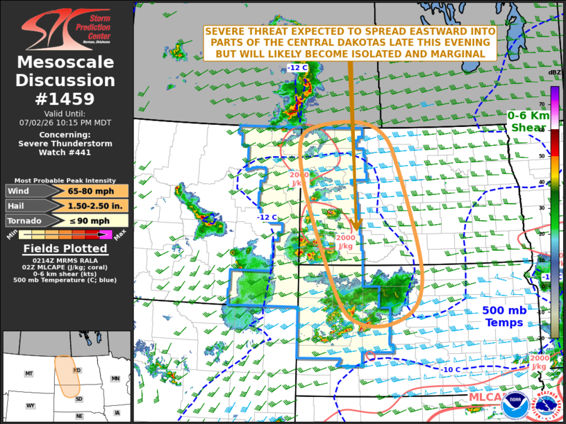
Mesoscale Discussion 1459 NWS Storm Prediction Center Norman OK 0917 PM CDT Thu Jul 02 2026 Areas affected...Western and Central North Dakota...Western and Central South Dakota Concerning...Severe Thunderstorm Watch 441... Valid 030217Z - 030415Z The severe weather threat for Severe Thunderstorm Watch 441 continues. SUMMARY...A severe threat is expected to continue across parts of the western Dakotas late this evening. Severe wind gusts and hail will be the primary threats. Additional weather watch issuance is not expected to the east of WW 441. DISCUSSION...Latest surface analysis shows a trough extending from near Rapid City north-northwestward into far eastern Montana. A moist airmass is located to the east of the trough over the western Dakotas, where dewpoints are mostly from the mid 50s to the mid 60s F. Because of this, an axis of moderate instability is analyzed by the RAP over the western Dakotas where MLCAPE is generally between 1500 to 3000 J/kg. Scattered storms, associated with a wind-damage and isolated large hail threat, are ongoing within this corridor of moderate instability. The storms are being supported by a subtle shortwave trough, evident on water vapor imagery. As the storms move eastward into weaker instability over the central Dakotas late this evening, the severe threat is expected to become more isolated. For this reason, additional weather watch issuance not expected. ..Broyles/Guyer.. 07/03/2026 ...Please see www.spc.noaa.gov for graphic product... ATTN...WFO...ABR...BIS...UNR...GGW... LAT...LON 44600120 44880044 45390012 46250018 48080083 48830130 49130218 49030350 48700406 47760393 46280332 45000265 44630205 44600120 MOST PROBABLE PEAK TORNADO INTENSITY...UP TO 90 MPH MOST PROBABLE PEAK WIND GUST...65-80 MPH MOST PROBABLE PEAK HAIL SIZE...1.50-2.50 IN |
|
|
Top/All Mesoscale Discussions/Forecast Products/Home |
|
Source link