| Mesoscale Discussion 1453 | |
| < Previous MD | |

|
|
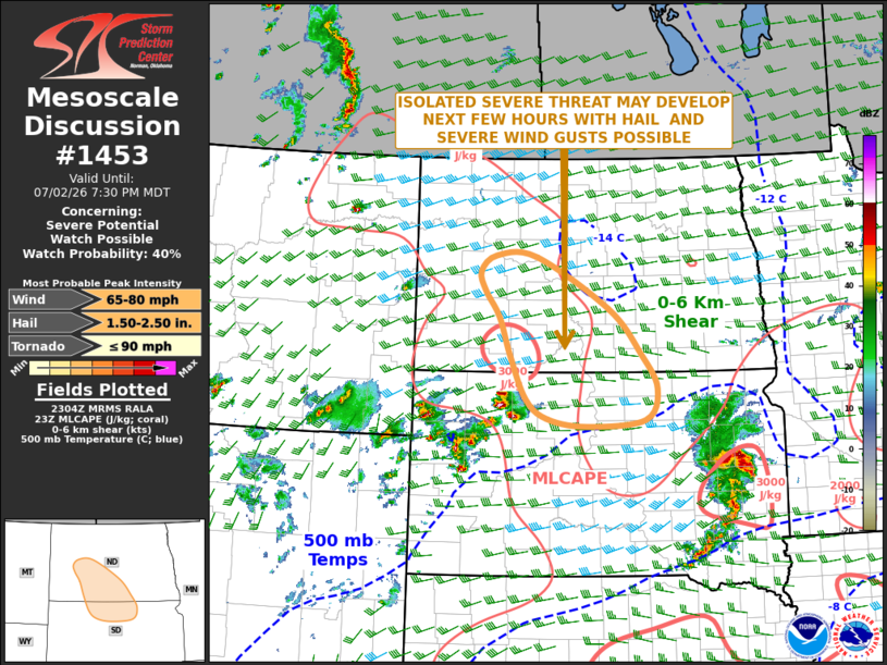
Mesoscale Discussion 1453 NWS Storm Prediction Center Norman OK 0607 PM CDT Thu Jul 02 2026 Areas affected...Northern South Dakota...Southern and Western North Dakota Concerning...Severe potential...Watch possible Valid 022307Z - 030130Z Probability of Watch Issuance...40 percent SUMMARY...An isolated severe threat may develop over parts of northern South Dakota and southern North Dakota over the next few hours. A weather watch extension in area may be needed across parts of northern South Dakota, or a new watch could need to be considered. DISCUSSION...The latest surface analysis show an axis of low-level moisture extending from central South Dakota into central and western North Dakota, where dewpoints are mostly in the lower to mid 60s F. Along that corridor, the RAP has MLCAPE in the 2000 to 3000 J/kg range. Thunderstorms have recently intensified in northwestern South Dakota just to the west of the instability axis, within the far eastern part of WW 441. Short-term model forecasts suggest that this activity will remain intact and move northeastward across parts of north-central South Dakota over the next couple of hours. Additional storms may also develop in parts of southern and western North Dakota. The storms that intensify in proximity of the instability axis could produce severe wind gusts and isolated large hail. ..Broyles/Guyer.. 07/02/2026 ...Please see www.spc.noaa.gov for graphic product... ATTN...WFO...ABR...BIS...UNR... LAT...LON 46209935 46850000 47600152 47610234 47390268 47100258 46740228 46180206 45540173 45260128 45150047 45249926 45709901 46209935 MOST PROBABLE PEAK TORNADO INTENSITY...UP TO 90 MPH MOST PROBABLE PEAK WIND GUST...65-80 MPH MOST PROBABLE PEAK HAIL SIZE...1.50-2.50 IN |
|
|
Top/All Mesoscale Discussions/Forecast Products/Home |
|
Source link