| Mesoscale Discussion 1449 | |
| < Previous MD Next MD > | |

|
|
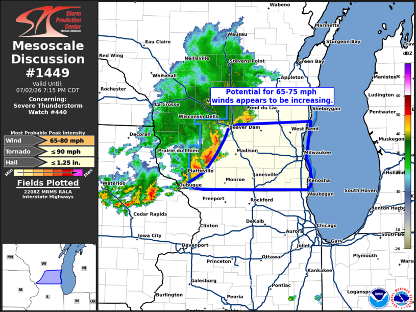
Mesoscale Discussion 1449 NWS Storm Prediction Center Norman OK 0510 PM CDT Thu Jul 02 2026 Areas affected...Southern Wisconsin Concerning...Severe Thunderstorm Watch 440... Valid 022210Z - 030015Z The severe weather threat for Severe Thunderstorm Watch 440 continues. SUMMARY...The potential for severe wind gusts should increase across southern Wisconsin over the next 1-2 hours. DISCUSSION...The development of a consolidated cold pool has become evident in velocity data from KARX and KMKX over the past hour. This appears to confirm the expected mode transition from broken cells to a more cohesive convective band/MCS. Downstream, the environment across southern WI is favorable for MCS maintenance with a pocket of 2000-2500 J/kg MLCAPE and around 30 knots of effective bulk shear in place per recent mesoanalyses and regional VWPs. Based on this parameter space, maximum wind speeds within the MCS may be as high as 65-75 mph (a recent 62 mph gust was noted at KLNR with the passage of the line). This threat appears most likely to manifest roughly along and just south of the I-94 corridor. 20 knot 0-3 km bulk shear vectors noted in regional VWPs are oriented roughly orthogonal to the developing line, which may support some brief circulations as well. ..Moore.. 07/02/2026 ...Please see www.spc.noaa.gov for graphic product... ATTN...WFO...LOT...MKX...DVN...ARX... LAT...LON 42589046 42789006 43078982 43318964 43478956 43558938 43608772 43228779 43008782 42828774 42648772 42538775 42498781 42489011 42509027 42589046 MOST PROBABLE PEAK TORNADO INTENSITY...UP TO 90 MPH MOST PROBABLE PEAK WIND GUST...65-80 MPH MOST PROBABLE PEAK HAIL SIZE...UP TO 1.25 IN |
|
|
Top/All Mesoscale Discussions/Forecast Products/Home |
|
Source link