| Mesoscale Discussion 1420 | |
| < Previous MD Next MD > | |

|
|
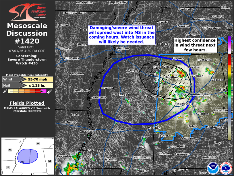
Mesoscale Discussion 1420 NWS Storm Prediction Center Norman OK 0233 PM CDT Wed Jul 01 2026 Areas affected...Western Alabama to central and northern Mississippi Concerning...Severe Thunderstorm Watch 430... Valid 011933Z - 012130Z The severe weather threat for Severe Thunderstorm Watch 430 continues. SUMMARY...Watch issuance is likely across central to northern Mississippi and thunderstorms spread west. DISCUSSION...The potential for severe winds may be increasing across northwest Alabama where two loosely organized convective clusters will likely interact and grow upscale in the coming hours. Both of these clusters are exhibiting continued re-development along their western outflows per regional radar imagery, and are propagating into an air mass that is very favorable for strong/severe downbursts (characterized by MLCAPE of around 4000 J/kg as well as steep low-level lapse rates on the order of 8 to 8.5 C/km). Consequently, the collision of these two clusters may result in a more focused corridor of thunderstorm development with a more robust/consolidated cold pool and a higher potential for damaging/severe winds. 25-30 knot mid-level flow continues to be sampled by regional VWPs, which should help any resulting cluster propagate downstream into northeast MS through late afternoon. Concurrently, additional thunderstorm development is noted along the MS/AL border with more shallow convective showers noted across central MS within a similar thermodynamic environment. Continued convective development is anticipated with this activity with an attendant threat for sporadic downburst winds. Severe thunderstorm watch issuance is expected in the coming hours across central/northern MS to address these concerns. ..Moore.. 07/01/2026 ...Please see www.spc.noaa.gov for graphic product... ATTN...WFO...BMX...HUN...MEG...JAN... LAT...LON 34968846 34788730 34528686 34078670 33548671 33098707 32708790 32588846 32548933 32678997 32929054 33299072 33769068 34249051 34679012 34868973 34968925 34998862 34968846 MOST PROBABLE PEAK WIND GUST...55-70 MPH MOST PROBABLE PEAK HAIL SIZE...UP TO 1.25 IN |
|
|
Top/All Mesoscale Discussions/Forecast Products/Home |
|
Source link