| Mesoscale Discussion 1416 | |
| < Previous MD | |

|
|
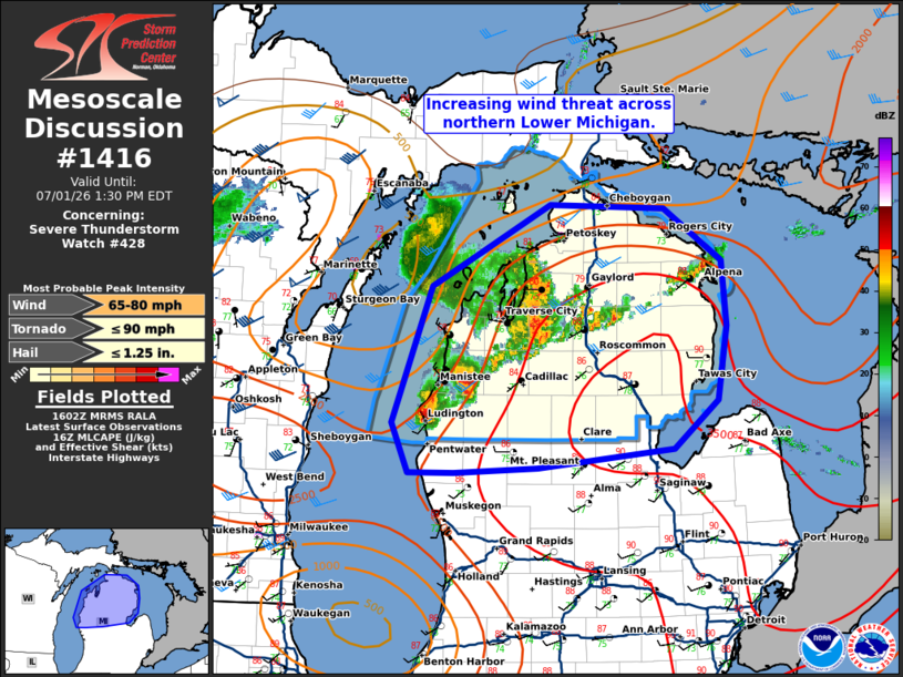
Mesoscale Discussion 1416 NWS Storm Prediction Center Norman OK 1105 AM CDT Wed Jul 01 2026 Areas affected...northern Michigan Concerning...Severe Thunderstorm Watch 428... Valid 011605Z - 011730Z The severe weather threat for Severe Thunderstorm Watch 428 continues. SUMMARY...The damaging wind threat across northern Michigan is increasing. DISCUSSION...The cluster of storms which produced severe wind gusts across eastern Wisconsin was sustained across Lake Michigan, albeit with lesser intensity, and has now produced an expansive cold pool which is moving across northern Michigan. The strongest storms have developed on the southern flank of this cold pool/outflow with these storms indicating moderate mid-level rotation. In addition, storms have developed along the frontal boundary across northern Michigan ahead of the storms farther west. Wind damage has been reported across parts of northwest Michigan and this portion of the line has since strengthened with a 43 knot wind gust measured at KTVC. Expect additional strengthening of the cold pool as it expands eastward into the afternoon into an increasingly unstable airmass with a continued damaging wind threat. Expect the stronger cores on the southern extent to maintain intensity as they move east and perhaps grow upscale into more of a bowing segment also. If this occurs, additional storms may eventually develop south of the current watch area and watch 428 may need to be locally expanded. ..Bentley.. 07/01/2026 ...Please see www.spc.noaa.gov for graphic product... ATTN...WFO...DTX...APX...GRR... LAT...LON 43948681 45018639 45648510 45618384 45208322 44708317 44118326 43748374 43588523 43548614 43548664 43948681 MOST PROBABLE PEAK TORNADO INTENSITY...UP TO 90 MPH MOST PROBABLE PEAK WIND GUST...65-80 MPH MOST PROBABLE PEAK HAIL SIZE...UP TO 1.25 IN |
|
|
Top/All Mesoscale Discussions/Forecast Products/Home |
|
Source link