| Mesoscale Discussion 1392 | |
| < Previous MD | |

|
|
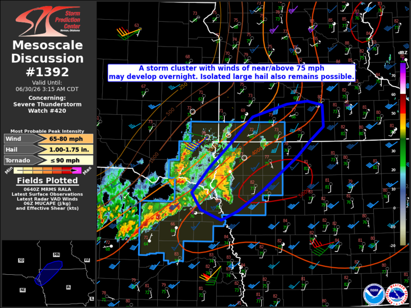
Mesoscale Discussion 1392 NWS Storm Prediction Center Norman OK 0142 AM CDT Tue Jun 30 2026 Areas affected...Northeast NE...southeast SD...northwest IA...southwest MN Concerning...Severe Thunderstorm Watch 420... Valid 300642Z - 300815Z The severe weather threat for Severe Thunderstorm Watch 420 continues. SUMMARY...A storm cluster with gusts of near/above 75 mph may develop overnight. Isolated hail also remains possible. Eventual downstream watch issuance may be needed. DISCUSSION...A small supercell cluster has recently shown some signs of upscale growth and northeastward acceleration across far northeast NE into southeast SD. This cluster may continue to move northeast overnight, along a pronounced moisture and buoyancy gradient that extends into south-central MN. Strong to extreme buoyancy and favorable deep-layer shear along/south of this boundary will continue to support organized convection through the overnight hours. The steep lapse rate and strong buoyancy environment is conditionally favorable for significant severe gusts (potentially 75-85 mph), though whether the ongoing cluster becomes sufficiently organized for more widespread gusts of this caliber remains uncertain. The strongest embedded cells will also remain capable of producing isolated large hail. Depending on the extent of organized upscale growth over the next 1-2 hours, downstream watch issuance may eventually be needed into parts of south-central MN and north-central IA. ..Dean/Smith.. 06/30/2026 ...Please see www.spc.noaa.gov for graphic product... ATTN...WFO...MPX...DMX...FSD...OAX... LAT...LON 42119637 42299686 42609707 43049667 43429621 43939563 44159479 44219429 44149394 43769391 43539421 43259453 42649538 42279598 42119637 MOST PROBABLE PEAK TORNADO INTENSITY...UP TO 90 MPH MOST PROBABLE PEAK WIND GUST...65-80 MPH MOST PROBABLE PEAK HAIL SIZE...1.00-1.75 IN |
|
|
Top/All Mesoscale Discussions/Forecast Products/Home |
|
Source link