| Mesoscale Discussion 1375 | |
| < Previous MD | |

|
|
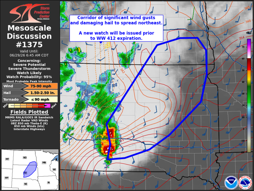
   Mesoscale Discussion 1375
   NWS Storm Prediction Center Norman OK
   0446 AM CDT Mon Jun 29 2026

   Areas affected...from central South Dakota into southeast North
   Dakota

   Concerning...Severe potential...Severe Thunderstorm Watch likely

   Valid 290946Z - 291145Z

   Probability of Watch Issuance...95 percent

   SUMMARY...The threat for damaging winds over 80 mph and wind-driven
   hail will spread northeastward out of central South Dakota into part
   of northeast South Dakota and southeast North Dakota.

   DISCUSSION...A severe cluster of storms over south-central SD has
   produced several gusts over 80 mph along with hail over 2.00"
   diameter. This system is expected to remain severe as it moves
   northeastward this morning. The anchor supercell on the southern end
   was previously moving almost due east, but recent radar trends
   suggest the system is finally moving more northeastward, similar to
   CAM guidance.

   The moist and unstable air mass, lift within the theta-e advection
   zone, and 50-60 kt deep-layer shear suggest the complex will remain
   severe for several more hours.

   ..Jewell.. 06/29/2026

   ...Please see www.spc.noaa.gov for graphic product...

   ATTN...WFO...FGF...FSD...ABR...BIS...UNR...

   LAT...LON   43310069 43740059 44300075 46489882 46669790 46669721
               46329687 45669687 44919712 44019835 43609911 43370003
               43310069

   MOST PROBABLE PEAK TORNADO INTENSITY...UP TO 90 MPH
   MOST PROBABLE PEAK WIND GUST...75-90 MPH
   MOST PROBABLE PEAK HAIL SIZE...1.50-2.50 IN
|
|
|
Top/All Mesoscale Discussions/Forecast Products/Home |
|
Source link