|
|
| Mesoscale Discussion 1375 | |
| < Previous MD Next MD > | |

|
|
   Mesoscale Discussion 1375
   NWS Storm Prediction Center Norman OK
   0332 PM CDT Sat Jun 22 2024

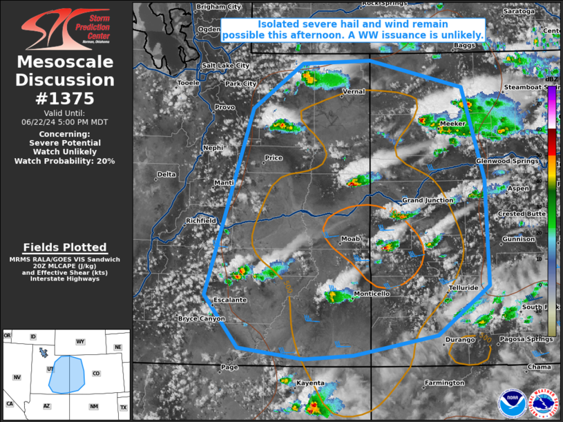
   Areas affected...portions of eastern Utah into western Colorado

   Concerning...Severe potential...Watch unlikely

   Valid 222032Z - 222300Z

   Probability of Watch Issuance...20 percent

   SUMMARY...The threat for isolated severe wind and hail is increasing
   across portions of eastern UT into western CO. A WW issuance is not
   currently expected.

   DISCUSSION...Thunderstorms are increasing in number and intensity
   across eastern UT/western CO along the entrance region of a 300 mb
   jet streak, where a well-mixed boundary layer is now in place.
   Latest MRMS-MESH radar data suggests some of the stronger storms may
   already be producing at least marginally severe (i.e. 1 inch
   diameter) hail. Surface temperatures approaching the upper 80s F
   beneath 9 C/km tropospheric lapse rates is contributing to 500-1000
   J/kg MLCAPE. RAP forecast soundings depict hodographs with modest
   low-level curvature but considerable mid-level elongation, which
   will promote continued multicell/supercell development through the
   afternoon. The strongest storms will be accompanied by some severe
   wind/hail threat. However, the severe threat should remain isolated,
   and a WW issuance is not currently anticipated.

   ..Squitieri/Hart.. 06/22/2024

   ...Please see www.spc.noaa.gov for graphic product...

   ATTN...WFO...GJT...SLC...

   LAT...LON   37901173 40281098 40861015 40900904 40550753 39370717
               38010711 37390795 37130931 37091013 37231119 37901173
|
|
|
Top/All Mesoscale Discussions/Forecast Products/Home |
|


