| Mesoscale Discussion 1353 | |
| < Previous MD | |

|
|
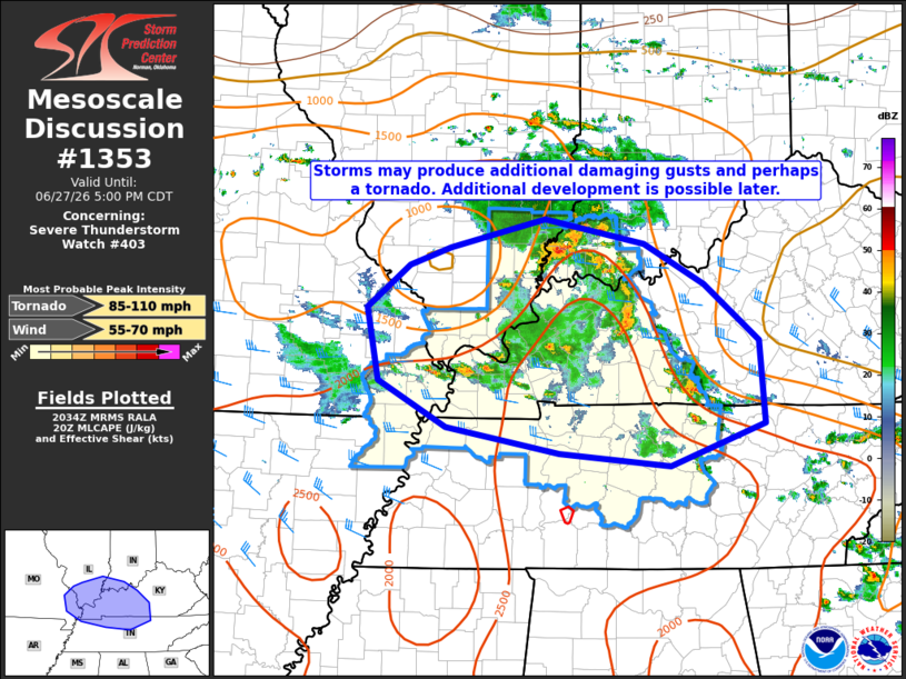
Mesoscale Discussion 1353 NWS Storm Prediction Center Norman OK 0336 PM CDT Sat Jun 27 2026 Areas affected...portions of southeastern Missouri...southern Illinois...western Kentucky...and northern Tennessee Concerning...Severe Thunderstorm Watch 403... Valid 272036Z - 272200Z The severe weather threat for Severe Thunderstorm Watch 403 continues. SUMMARY...Clusters of storms have produced a couple damaging gusts across portions of southeastern Missouri, southern Illinois, western Kentucky, and northern Tennessee. Additional redevelopment is possible to the west. DISCUSSION...An MCV is tracking eastward across portions of the mid-Mississippi Valley this afternoon, and a compact but relatively intense mid-level jet streak of 50+ kts is being sampled by the KPAH and KHPX VWPs. This is contributing to relatively strong bulk shear of 30-40 kts across the region, enough for occasional mini-supercell structures to appear on WSR-88Ds. Given the relatively strong mid-level flow a few damaging gusts and perhaps a tornado or two may continue to occur with this activity. Additional activity may develop across portions of southern Missouri in association with another MCV and move into the western portions of Watch 403 later this afternoon and evening. Latest HRRR and RRFS runs are split on whether this actually occurs, and visible satellite in the area shows widespread cloud cover with cumulus development not looking particularly imminent. However, should additional development occur, the environment will continue to be favorable for additional damaging gusts and perhaps a tornado or two. ..Supinie/Guyer.. 06/27/2026 ...Please see www.spc.noaa.gov for graphic product... ATTN...WFO...LMK...OHX...IND...PAH...MEG...LSX... LAT...LON 38218917 38508797 38258672 37848598 37268529 36448523 36018641 36158779 36408921 36879006 37609020 38028967 38218917 MOST PROBABLE PEAK TORNADO INTENSITY...85-110 MPH MOST PROBABLE PEAK WIND GUST...55-70 MPH |
|
|
Top/All Mesoscale Discussions/Forecast Products/Home |
|
Source link