| Mesoscale Discussion 1345 | |
| < Previous MD | |

|
|
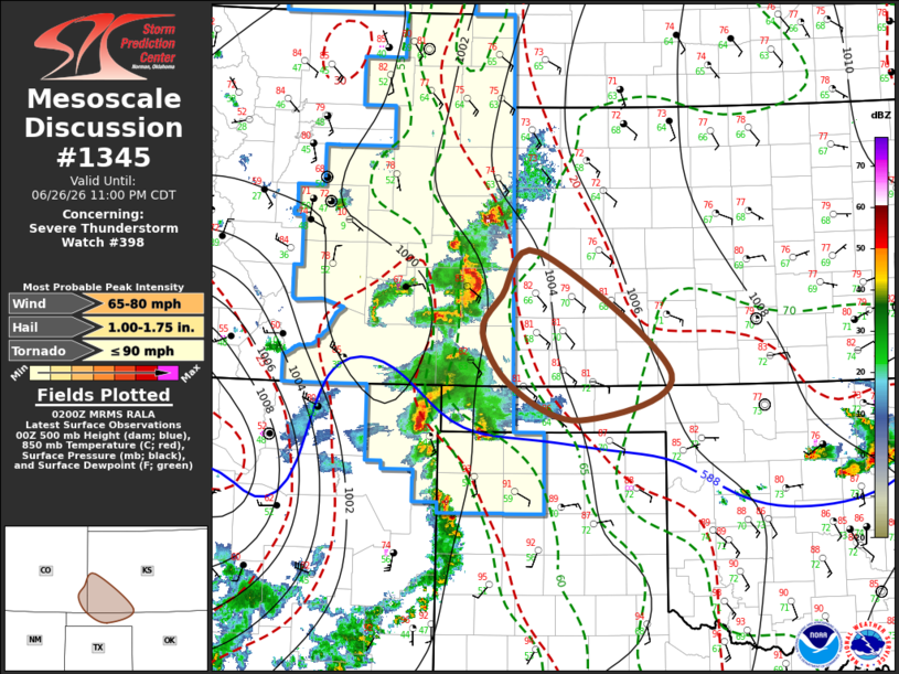
Mesoscale Discussion 1345 NWS Storm Prediction Center Norman OK 0902 PM CDT Fri Jun 26 2026 Areas affected...parts of southeastern Colorado...southwestern Kansas and adjacent portions of the high plains Concerning...Severe Thunderstorm Watch 398... Valid 270202Z - 270400Z The severe weather threat for Severe Thunderstorm Watch 398 continues. SUMMARY...An evolving cluster of storms may organize further and become accompanied by increasing potential to produce strong to severe gusts through 10-11 PM CDT. DISCUSSION...Convection has continued to grow upscale within a narrow corridor of moderate to strong potential instability across the high plains. Southeastward across southwestern Kansas into northwestern Oklahoma, this is focused along a remnant baroclinic zone associated with stronger differential daytime heating. The boundary layer has begun to slowly cool either side of this baroclinic zone, and there appears at least subtle continuing warming associated with elevated mixed-layer air spreading east of the Rockies, contributing to increasing inhibition. However, another weak short wave impulse on the southern fringe of the westerlies is slowly overspreading the Raton Mesa/ridging vicinity, which may suppress larger-scale mid-level height rise this evening. Given favorable deep-layer shear, due to pronounced veering of low-level east-southeasterly flow to modest westerlies, there appears at least some potential for convection to organize further as it continues to consolidate. This may be accompanied by a strengthening cold pool, which should tend to propagate east-southeastward along the low-level baroclinic zone. ..Kerr.. 06/27/2026 ...Please see www.spc.noaa.gov for graphic product... ATTN...WFO...DDC...GLD...AMA...PUB... LAT...LON 37960220 38430168 37119991 36620113 36980206 37560246 37960220 MOST PROBABLE PEAK TORNADO INTENSITY...UP TO 90 MPH MOST PROBABLE PEAK WIND GUST...65-80 MPH MOST PROBABLE PEAK HAIL SIZE...1.00-1.75 IN |
|
|
Top/All Mesoscale Discussions/Forecast Products/Home |
|
Source link